Localities
... or show all sections
Nurme borehole
Show additional data in Estonian Geocollections Portal
|
References (2)
Raw data (35 species, 68 samples)
locality	depth	depth_interval	sample_number	Cyathochitina campanulaeformis	Plectochitina spongiosa	Belonechitina postrobusta	Euconochitina electa	Conochitina iklaensis	Conochitina elongata	Conochitina alargada	Conochitina edjelensis	Ancyrochitina convexa	Conochitina malleus	Conochitina sp. 4 (Nestor, 1994)	Rhabdochitina sp. 2 (Nestor et al., 2003)	Bursachitina conica	Bursachitina nestorae	Belonechitina cavei	Conochitina visbyensis	Conochitina praeproboscifera	Ancyrochitina rumbaensis	Conochitina emmastensis	Belonechitina oeselensis	Conochitina leviscapulae	Belonechitina meifodensis	Ancyrochitina porrectaspina	Plectochitina pachyderma	Eisenackitina causiata 	Eisenackitina dolioliformis	Eisenackitina inanulifera	Angochitina longicollis	Conochitina leptosoma	Ancyrochitina mullinsi	Ancyrochitina vikiensis	Ramochitina ruhnuensis	Margachitina banwyensis	Calpichitina densa	Conochitina proboscifera
Nurme puurauk	1.00	1.20	M-11107																												1						-1	1
Nurme puurauk	1.80	1.90	M-11106																										-1	-1	1						-1	-1
Nurme puurauk	2.45	2.55	M-11105																1						-1			1		1	1						-1	1
Nurme puurauk	3.15	3.26	M-11104														-1	-1							-1				-1		-1							1
Nurme puurauk	3.85	3.95	M-11103															-1							-1			1	1	1	1							-1
Nurme puurauk	4.55	4.70	M-11102																						-1						1
Nurme puurauk	5.10	5.25	M-11101																											1	1							1
Nurme puurauk	6.25	6.40	M-11100																						-1		-1				1
Nurme puurauk	7.30	7.45	M-11099															-1										1			1
Nurme puurauk	9.60	9.70	M-11108															-1										-1		-1	1
Nurme puurauk	10.10	10.25	M-11098															-1						-1							1
Nurme puurauk	11.05	11.20	M-11097															-1	1					1	1			1	1		1
Nurme puurauk	11.90	12.00	M-11096															-1	1												-1
Nurme puurauk	12.70	12.85	M-11095													1	-1	1					1					1			1
Nurme puurauk	13.30	13.40	M-11094															-1							-1						1				1	-1	1
Nurme puurauk	13.85	14.00	M-11093															-1							1			1	1	1					1
Nurme puurauk	14.80	14.90	M-11092															-1							1			1	-1	1				-1
Nurme puurauk	15.63	15.75	M-12885															-1							1			1	-1	1
Nurme puurauk	16.45	16.65	M-11091													-1		-1		-1					1			1	1	1			-1	-1
Nurme puurauk	24.55	24.65	M-11090													1	1	-1				-1	-1	-1	1			1	1	1
Nurme puurauk	25.17	25.27	M-11089													1	1	-1							1			1	1	1	-1	-1
Nurme puurauk	29.10	29.20	M-11087													1	-1	-1	-1				1		1		-1	1	1	-1	1	-1
Nurme puurauk	29.50	29.60	M-11088													1		-1				1	1		-1	1	-1	-1	1	-1	-1
Nurme puurauk	30.85	31.00	M-12884													1		-1	-1	-1	1	1	-1		-1
Nurme puurauk	31.25	31.35	M-12883													1	1	-1	1	1	1	1	-1	1
Nurme puurauk	34.80	35.10	M-11086														-1	-1		1
Nurme puurauk	35.10	35.20	M-12882											1	-1	-1	-1	-1		1
Nurme puurauk	36.00	36.15	M-12881											1		1		-1	-1
Nurme puurauk	37.30	37.45	M-12880											1		1	1
Nurme puurauk	37.95	38.00	M-12879											1			1
Nurme puurauk	38.95	39.00	M-12878						-1					1	1	-1	1
Nurme puurauk	39.60	39.75	M-12877						-1					1
Nurme puurauk	40.50	40.65	M-12876						-1				1	1
Nurme puurauk	45.70	45.85	M-12875						1		-1
Nurme puurauk	47.20	47.35	M-12874						1		1		-1
Nurme puurauk	48.30	48.40	M-9820						1		1		-1
Nurme puurauk	48.50	48.65	M-12873						1	1	1
Nurme puurauk	50.30	50.45	M-9858						1		1
Nurme puurauk	51.45	51.60	M-9857						1		1
Nurme puurauk	51.60	51.75	M-9821						1		1
Nurme puurauk	52.65	52.80	M-9856						1		1	-1
Nurme puurauk	53.40	53.55	M-9855						1	1	1
Nurme puurauk	53.70	53.80	M-9822					1	1	-1	1
Nurme puurauk	54.80	55.05	M-9854					1	1
Nurme puurauk	59.00	59.15	M-9853		-1
Nurme puurauk	72.20	72.35	M-9826
Nurme puurauk	73.80	73.95	M-9827
Nurme puurauk	75.80	76.00	M-9828				-1
Nurme puurauk	77.40	77.55	M-9829
Nurme puurauk	79.40	79.55	M-9830	-1
Nurme puurauk	83.00	83.10	M-9831
Nurme puurauk	84.50		M-9832			-1
Nurme puurauk	85.25	85.40	M-9833	-1
Nurme puurauk	86.80	86.90	M-9834
Nurme puurauk	87.20	87.30	M-9835
Nurme puurauk	88.40	88.50	M-9836
Nurme puurauk	92.00	92.10	M-9837
Nurme puurauk	94.20	94.30	M-9838
Nurme puurauk	97.10	97.20	M-9839
Nurme puurauk	100.30	100.40	M-9840
Nurme puurauk	102.30	102.50	M-9841
Nurme puurauk	104.10	104.20	M-9842	1	1
Nurme puurauk	105.60	105.70	M-9843
Nurme puurauk	106.90	107.00	M-9844	1
Nurme puurauk	109.30	109.40	M-9846	1	-1
Nurme puurauk	110.20	110.30	M-9847	1	-1
Nurme puurauk	111.00	111.10	M-9848
Nurme puurauk	111.40	111.50	M-9849
| locality | depth | depth_interval | sample_number | Cyathochitina campanulaeformis | Plectochitina spongiosa | Belonechitina postrobusta | Euconochitina electa | Conochitina iklaensis | Conochitina elongata | Conochitina alargada | Conochitina edjelensis | Ancyrochitina convexa | Conochitina malleus | Conochitina sp. 4 (Nestor, 1994) | Rhabdochitina sp. 2 (Nestor et al., 2003) | Bursachitina conica | Bursachitina nestorae | Belonechitina cavei | Conochitina visbyensis | Conochitina praeproboscifera | Ancyrochitina rumbaensis | Conochitina emmastensis | Belonechitina oeselensis | Conochitina leviscapulae | Belonechitina meifodensis | Ancyrochitina porrectaspina | Plectochitina pachyderma | Eisenackitina causiata | Eisenackitina dolioliformis | Eisenackitina inanulifera | Angochitina longicollis | Conochitina leptosoma | Ancyrochitina mullinsi | Ancyrochitina vikiensis | Ramochitina ruhnuensis | Margachitina banwyensis | Calpichitina densa | Conochitina proboscifera |
|---|---|---|---|---|---|---|---|---|---|---|---|---|---|---|---|---|---|---|---|---|---|---|---|---|---|---|---|---|---|---|---|---|---|---|---|---|---|---|
| Nurme puurauk | 1.00 | 1.20 | M-11107 | 1 | -1 | 1 | ||||||||||||||||||||||||||||||||
| Nurme puurauk | 1.80 | 1.90 | M-11106 | -1 | -1 | 1 | -1 | -1 | ||||||||||||||||||||||||||||||
| Nurme puurauk | 2.45 | 2.55 | M-11105 | 1 | -1 | 1 | 1 | 1 | -1 | 1 | ||||||||||||||||||||||||||||
| Nurme puurauk | 3.15 | 3.26 | M-11104 | -1 | -1 | -1 | -1 | -1 | 1 | |||||||||||||||||||||||||||||
| Nurme puurauk | 3.85 | 3.95 | M-11103 | -1 | -1 | 1 | 1 | 1 | 1 | -1 | ||||||||||||||||||||||||||||
| Nurme puurauk | 4.55 | 4.70 | M-11102 | -1 | 1 | |||||||||||||||||||||||||||||||||
| Nurme puurauk | 5.10 | 5.25 | M-11101 | 1 | 1 | 1 | ||||||||||||||||||||||||||||||||
| Nurme puurauk | 6.25 | 6.40 | M-11100 | -1 | -1 | 1 | ||||||||||||||||||||||||||||||||
| Nurme puurauk | 7.30 | 7.45 | M-11099 | -1 | 1 | 1 | ||||||||||||||||||||||||||||||||
| Nurme puurauk | 9.60 | 9.70 | M-11108 | -1 | -1 | -1 | 1 | |||||||||||||||||||||||||||||||
| Nurme puurauk | 10.10 | 10.25 | M-11098 | -1 | -1 | 1 | ||||||||||||||||||||||||||||||||
| Nurme puurauk | 11.05 | 11.20 | M-11097 | -1 | 1 | 1 | 1 | 1 | 1 | 1 | ||||||||||||||||||||||||||||
| Nurme puurauk | 11.90 | 12.00 | M-11096 | -1 | 1 | -1 | ||||||||||||||||||||||||||||||||
| Nurme puurauk | 12.70 | 12.85 | M-11095 | 1 | -1 | 1 | 1 | 1 | 1 | |||||||||||||||||||||||||||||
| Nurme puurauk | 13.30 | 13.40 | M-11094 | -1 | -1 | 1 | 1 | -1 | 1 | |||||||||||||||||||||||||||||
| Nurme puurauk | 13.85 | 14.00 | M-11093 | -1 | 1 | 1 | 1 | 1 | 1 | |||||||||||||||||||||||||||||
| Nurme puurauk | 14.80 | 14.90 | M-11092 | -1 | 1 | 1 | -1 | 1 | -1 | |||||||||||||||||||||||||||||
| Nurme puurauk | 15.63 | 15.75 | M-12885 | -1 | 1 | 1 | -1 | 1 | ||||||||||||||||||||||||||||||
| Nurme puurauk | 16.45 | 16.65 | M-11091 | -1 | -1 | -1 | 1 | 1 | 1 | 1 | -1 | -1 | ||||||||||||||||||||||||||
| Nurme puurauk | 24.55 | 24.65 | M-11090 | 1 | 1 | -1 | -1 | -1 | -1 | 1 | 1 | 1 | 1 | |||||||||||||||||||||||||
| Nurme puurauk | 25.17 | 25.27 | M-11089 | 1 | 1 | -1 | 1 | 1 | 1 | 1 | -1 | -1 | ||||||||||||||||||||||||||
| Nurme puurauk | 29.10 | 29.20 | M-11087 | 1 | -1 | -1 | -1 | 1 | 1 | -1 | 1 | 1 | -1 | 1 | -1 | |||||||||||||||||||||||
| Nurme puurauk | 29.50 | 29.60 | M-11088 | 1 | -1 | 1 | 1 | -1 | 1 | -1 | -1 | 1 | -1 | -1 | ||||||||||||||||||||||||
| Nurme puurauk | 30.85 | 31.00 | M-12884 | 1 | -1 | -1 | -1 | 1 | 1 | -1 | -1 | |||||||||||||||||||||||||||
| Nurme puurauk | 31.25 | 31.35 | M-12883 | 1 | 1 | -1 | 1 | 1 | 1 | 1 | -1 | 1 | ||||||||||||||||||||||||||
| Nurme puurauk | 34.80 | 35.10 | M-11086 | -1 | -1 | 1 | ||||||||||||||||||||||||||||||||
| Nurme puurauk | 35.10 | 35.20 | M-12882 | 1 | -1 | -1 | -1 | -1 | 1 | |||||||||||||||||||||||||||||
| Nurme puurauk | 36.00 | 36.15 | M-12881 | 1 | 1 | -1 | -1 | |||||||||||||||||||||||||||||||
| Nurme puurauk | 37.30 | 37.45 | M-12880 | 1 | 1 | 1 | ||||||||||||||||||||||||||||||||
| Nurme puurauk | 37.95 | 38.00 | M-12879 | 1 | 1 | |||||||||||||||||||||||||||||||||
| Nurme puurauk | 38.95 | 39.00 | M-12878 | -1 | 1 | 1 | -1 | 1 | ||||||||||||||||||||||||||||||
| Nurme puurauk | 39.60 | 39.75 | M-12877 | -1 | 1 | |||||||||||||||||||||||||||||||||
| Nurme puurauk | 40.50 | 40.65 | M-12876 | -1 | 1 | 1 | ||||||||||||||||||||||||||||||||
| Nurme puurauk | 45.70 | 45.85 | M-12875 | 1 | -1 | |||||||||||||||||||||||||||||||||
| Nurme puurauk | 47.20 | 47.35 | M-12874 | 1 | 1 | -1 | ||||||||||||||||||||||||||||||||
| Nurme puurauk | 48.30 | 48.40 | M-9820 | 1 | 1 | -1 | ||||||||||||||||||||||||||||||||
| Nurme puurauk | 48.50 | 48.65 | M-12873 | 1 | 1 | 1 | ||||||||||||||||||||||||||||||||
| Nurme puurauk | 50.30 | 50.45 | M-9858 | 1 | 1 | |||||||||||||||||||||||||||||||||
| Nurme puurauk | 51.45 | 51.60 | M-9857 | 1 | 1 | |||||||||||||||||||||||||||||||||
| Nurme puurauk | 51.60 | 51.75 | M-9821 | 1 | 1 | |||||||||||||||||||||||||||||||||
| Nurme puurauk | 52.65 | 52.80 | M-9856 | 1 | 1 | -1 | ||||||||||||||||||||||||||||||||
| Nurme puurauk | 53.40 | 53.55 | M-9855 | 1 | 1 | 1 | ||||||||||||||||||||||||||||||||
| Nurme puurauk | 53.70 | 53.80 | M-9822 | 1 | 1 | -1 | 1 | |||||||||||||||||||||||||||||||
| Nurme puurauk | 54.80 | 55.05 | M-9854 | 1 | 1 | |||||||||||||||||||||||||||||||||
| Nurme puurauk | 59.00 | 59.15 | M-9853 | -1 | ||||||||||||||||||||||||||||||||||
| Nurme puurauk | 72.20 | 72.35 | M-9826 | |||||||||||||||||||||||||||||||||||
| Nurme puurauk | 73.80 | 73.95 | M-9827 | |||||||||||||||||||||||||||||||||||
| Nurme puurauk | 75.80 | 76.00 | M-9828 | -1 | ||||||||||||||||||||||||||||||||||
| Nurme puurauk | 77.40 | 77.55 | M-9829 | |||||||||||||||||||||||||||||||||||
| Nurme puurauk | 79.40 | 79.55 | M-9830 | -1 | ||||||||||||||||||||||||||||||||||
| Nurme puurauk | 83.00 | 83.10 | M-9831 | |||||||||||||||||||||||||||||||||||
| Nurme puurauk | 84.50 | M-9832 | -1 | |||||||||||||||||||||||||||||||||||
| Nurme puurauk | 85.25 | 85.40 | M-9833 | -1 | ||||||||||||||||||||||||||||||||||
| Nurme puurauk | 86.80 | 86.90 | M-9834 | |||||||||||||||||||||||||||||||||||
| Nurme puurauk | 87.20 | 87.30 | M-9835 | |||||||||||||||||||||||||||||||||||
| Nurme puurauk | 88.40 | 88.50 | M-9836 | |||||||||||||||||||||||||||||||||||
| Nurme puurauk | 92.00 | 92.10 | M-9837 | |||||||||||||||||||||||||||||||||||
| Nurme puurauk | 94.20 | 94.30 | M-9838 | |||||||||||||||||||||||||||||||||||
| Nurme puurauk | 97.10 | 97.20 | M-9839 | |||||||||||||||||||||||||||||||||||
| Nurme puurauk | 100.30 | 100.40 | M-9840 | |||||||||||||||||||||||||||||||||||
| Nurme puurauk | 102.30 | 102.50 | M-9841 | |||||||||||||||||||||||||||||||||||
| Nurme puurauk | 104.10 | 104.20 | M-9842 | 1 | 1 | |||||||||||||||||||||||||||||||||
| Nurme puurauk | 105.60 | 105.70 | M-9843 | |||||||||||||||||||||||||||||||||||
| Nurme puurauk | 106.90 | 107.00 | M-9844 | 1 | ||||||||||||||||||||||||||||||||||
| Nurme puurauk | 109.30 | 109.40 | M-9846 | 1 | -1 | |||||||||||||||||||||||||||||||||
| Nurme puurauk | 110.20 | 110.30 | M-9847 | 1 | -1 | |||||||||||||||||||||||||||||||||
| Nurme puurauk | 111.00 | 111.10 | M-9848 | |||||||||||||||||||||||||||||||||||
| Nurme puurauk | 111.40 | 111.50 | M-9849 |
Show table
Range chart (autogenerated)
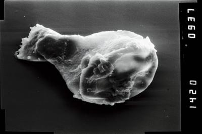
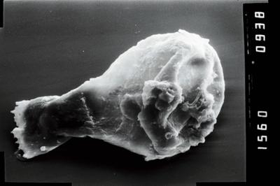
Photos
Tooltip: to show larger image hold Ctrl-key when clicking on image.