Localities
Sõru 400 borehole Show additional data in Estonian Geocollections Portal ID 1326 Name Sõru 400 borehole Number 400 Loc. type borehole (section) Country Estonia County Hiiu County Parish Emmaste Settlement Pärna Elevation (m) 1.00 Latitude (dec. deg.) 58.694052 Longitude (dec. deg.) 22.521623 X (m, L-EST 97) 6506982 Y (m, L-EST 97) 414290 Coord. agent Eesti Geoloogiakeskus (EGK) Location remarks Sõru sadamakai lähedal Vertical extent (m) 420.70 Stratigraphy top Adavere Stage Stratigraphy top freeform Rumba Stratigraphy base Proterozoic Maaamet ID 1069 Remarks Puuritud 1971 kaardistam; EGF 3146 Record changed 2022-11-21 21:13:15
References (2) Nestor, V. 1976 . Сопоставление некоторых разрезов райккюлаского горизонта Эстонии по микропланктону [A microplankton correlation of boring sections of the Raikküla Stage, Estonia]. Eesti NSV Teaduste Akadeemia Toimetised. Keemia, Geoloogia / Известия Академии наук Эстонской ССР. Химия. Геология 25 (4), 319-323. | DOI | DETAILS
Nestor, V. 1994 . Early Silurian chitinozoans of Estonia and North Latvia. Estonian Academy Publishers, Tallinn. 1-163. | DETAILS
Raw data (26 species, 76 samples) locality depth depth_interval sample_number Plectochitina spongiosa Cyathochitina campanulaeformis Belonechitina postrobusta Euconochitina electa Cyathochitina kuckersiana Ancyrochitina bifurcaspina Conochitina iklaensis Belonechitina aspera Ancyrochitina convexa Conochitina alargada Conochitina elongata Conochitina edjelensis Plectochitina ralphi Conochitina malleus Conochitina praeproboscifera Conochitina sp. 4 (Nestor, 1994) Belonechitina meifodensis Bursachitina sp. 1 (M & L, 2001) Conochitina leptosoma Plectochitina pachyderma Bursachitina conica Bursachitina nestorae Angochitina hansonica Conochitina emmastensis Ramochitina angusta Conochitina visbyensis
Sõru 400 borehole 1.00 1.00 M-18267 -1 -1 -1 1 1 -1 -1
Sõru 400 borehole 2.10 2.10 M-18266 1
Sõru 400 borehole 3.60 3.60 M-18265 -1 1 1 -1 1
Sõru 400 borehole 5.40 5.40 M-18264 -1 1 -1 1 1 1 1
Sõru 400 borehole 6.50 6.50 M-18263 -1 -1 1 1 -1 -1
Sõru 400 borehole 7.65 7.65 M-18262 1 -1 -1
Sõru 400 borehole 22.70 22.70 M-18261 -1
Sõru 400 borehole 24.80 24.80 M-18260 1
Sõru 400 borehole 26.60 26.60 M-18259 -1
Sõru 400 borehole 28.30 28.30 M-18258 1 1
Sõru 400 borehole 31.30 31.30 M-18257 1
Sõru 400 borehole 33.00 33.00 M-18256 1 -1 1 -1
Sõru 400 borehole 33.50 33.60 M-1203 -1 1 1 -1
Sõru 400 borehole 33.80 M-1204 1 -1 -1 1 1 1
Sõru 400 borehole 34.00 34.00 M-18255 1 -1 1 1
Sõru 400 borehole 34.20 M-1205 1 1 1 -1 1 1 -1
Sõru 400 borehole 34.56 34.65 M-1206 1 1 1 -1 1
Sõru 400 borehole 34.75 M-1207 1 1 1 -1
Sõru 400 borehole 35.15 35.23 M-1208 1 1 1 -1
Sõru 400 borehole 35.40 35.50 M-1209 1 1 1 -1
Sõru 400 borehole 35.70 35.70 M-18254 -1
Sõru 400 borehole 36.30 36.40 M-1210 1 1 -1 -1
Sõru 400 borehole 36.80 M-1211 1 1 -1
Sõru 400 borehole 37.10 37.15 M-1212 1 1 1
Sõru 400 borehole 37.30 37.50 M-1213 1 1 -1 -1
Sõru 400 borehole 38.20 38.25 M-1214 -1 1 1 1 1
Sõru 400 borehole 39.33 M-1215 1 1 1
Sõru 400 borehole 39.60 39.60 M-18253 1 1 -1 -1 1
Sõru 400 borehole 39.61 39.66 M-1216 1 1
Sõru 400 borehole 39.91 39.99 M-1217 1
Sõru 400 borehole 40.20 M-1218 1
Sõru 400 borehole 41.22 41.30 M-1220 1 -1
Sõru 400 borehole 42.30 M-1221 1
Sõru 400 borehole 43.20 M-1222 1
Sõru 400 borehole 43.70 43.70 M-18252 1 -1
Sõru 400 borehole 44.00 M-1223 -1
Sõru 400 borehole 44.60 44.70 M-1224 1 1
Sõru 400 borehole 45.40 M-1225 1 1
Sõru 400 borehole 46.65 46.75 M-1226 1
Sõru 400 borehole 48.00 48.00 M-18251 1
Sõru 400 borehole 48.80 M-1228 1
Sõru 400 borehole 49.80 49.90 M-1229 -1 1
Sõru 400 borehole 50.50 M-1230 1
Sõru 400 borehole 53.50 53.60 M-1232 -1 1 1 -1
Sõru 400 borehole 53.90 M-1233 1 1 1
Sõru 400 borehole 54.10 54.20 M-1234 1 1 -1
Sõru 400 borehole 54.35 M-1235 1 1
Sõru 400 borehole 54.89 54.92 M-1236 1 1 1
Sõru 400 borehole 55.00 55.20 M-1237 1 1
Sõru 400 borehole 56.05 56.10 M-1238 1 1
Sõru 400 borehole 57.00 M-1239 1 1
Sõru 400 borehole 58.10 M-1240
Sõru 400 borehole 58.35 58.40 M-1241 1 1 1 1
Sõru 400 borehole 60.20 M-1243 -1 -1
Sõru 400 borehole 60.85 M-1244
Sõru 400 borehole 61.05 M-1245 1
Sõru 400 borehole 62.00 M-1246
Sõru 400 borehole 63.10 M-1247
Sõru 400 borehole 63.90 M-1248
Sõru 400 borehole 64.60 64.70 M-1249
Sõru 400 borehole 65.23 65.32 M-1250
Sõru 400 borehole 67.00 M-1251
Sõru 400 borehole 68.05 M-1252
Sõru 400 borehole 69.75 M-1253
Sõru 400 borehole 69.80 M-1254
Sõru 400 borehole 70.10 M-1255
Sõru 400 borehole 70.70 M-1257
Sõru 400 borehole 70.80 M-1258 1
Sõru 400 borehole 71.00 M-1259 -1
Sõru 400 borehole 72.85 M-1260
Sõru 400 borehole 72.90 M-1261 -1
Sõru 400 borehole 73.00 M-1262
Sõru 400 borehole 73.33 73.40 M-1263
Sõru 400 borehole 73.80 M-1265 1
Sõru 400 borehole 74.10 M-1266 1
Sõru 400 borehole 77.10 77.20 M-1268
locality	depth	depth_interval	sample_number	Plectochitina spongiosa	Cyathochitina campanulaeformis	Belonechitina postrobusta	Euconochitina electa	Cyathochitina kuckersiana	Ancyrochitina bifurcaspina	Conochitina iklaensis	Belonechitina aspera	Ancyrochitina convexa	Conochitina alargada	Conochitina elongata	Conochitina edjelensis	Plectochitina ralphi	Conochitina malleus	Conochitina praeproboscifera	Conochitina sp. 4 (Nestor, 1994)	Belonechitina meifodensis	Bursachitina sp. 1 (M & L, 2001)	Conochitina leptosoma	Plectochitina pachyderma	Bursachitina conica	Bursachitina nestorae	Angochitina hansonica	Conochitina emmastensis	Ramochitina angusta	Conochitina visbyensis
Sõru 400 borehole	1.00	1.00	M-18267															-1			-1			-1	1		1	-1	-1
Sõru 400 borehole	2.10	2.10	M-18266															1
Sõru 400 borehole	3.60	3.60	M-18265																-1					1	1		-1	1
Sõru 400 borehole	5.40	5.40	M-18264																-1	1				-1	1	1	1	1
Sõru 400 borehole	6.50	6.50	M-18263															-1		-1		1	1	-1	-1
Sõru 400 borehole	7.65	7.65	M-18262															1		-1	-1
Sõru 400 borehole	22.70	22.70	M-18261											-1
Sõru 400 borehole	24.80	24.80	M-18260															1
Sõru 400 borehole	26.60	26.60	M-18259											-1
Sõru 400 borehole	28.30	28.30	M-18258										1	1
Sõru 400 borehole	31.30	31.30	M-18257											1
Sõru 400 borehole	33.00	33.00	M-18256									1	-1	1	-1
Sõru 400 borehole	33.50	33.60	M-1203		-1			1									1	-1
Sõru 400 borehole	33.80		M-1204					1					-1	-1			1	1	1
Sõru 400 borehole	34.00	34.00	M-18255									1	-1	1	1
Sõru 400 borehole	34.20		M-1205					1		1			1	-1			1	1	-1
Sõru 400 borehole	34.56	34.65	M-1206							1			1	1			-1	1
Sõru 400 borehole	34.75		M-1207							1			1	1			-1
Sõru 400 borehole	35.15	35.23	M-1208							1			1	1			-1
Sõru 400 borehole	35.40	35.50	M-1209							1			1	1			-1
Sõru 400 borehole	35.70	35.70	M-18254				-1
Sõru 400 borehole	36.30	36.40	M-1210							1			1	-1		-1
Sõru 400 borehole	36.80		M-1211							1			1	-1
Sõru 400 borehole	37.10	37.15	M-1212							1			1	1
Sõru 400 borehole	37.30	37.50	M-1213							1			1	-1	-1
Sõru 400 borehole	38.20	38.25	M-1214					-1		1			1	1	1
Sõru 400 borehole	39.33		M-1215				1	1		1
Sõru 400 borehole	39.60	39.60	M-18253				1	1				-1	-1	1
Sõru 400 borehole	39.61	39.66	M-1216				1			1
Sõru 400 borehole	39.91	39.99	M-1217				1
Sõru 400 borehole	40.20		M-1218				1
Sõru 400 borehole	41.22	41.30	M-1220				1			-1
Sõru 400 borehole	42.30		M-1221					1
Sõru 400 borehole	43.20		M-1222					1
Sõru 400 borehole	43.70	43.70	M-18252				1				-1
Sõru 400 borehole	44.00		M-1223					-1
Sõru 400 borehole	44.60	44.70	M-1224		1			1
Sõru 400 borehole	45.40		M-1225				1	1
Sõru 400 borehole	46.65	46.75	M-1226					1
Sõru 400 borehole	48.00	48.00	M-18251					1
Sõru 400 borehole	48.80		M-1228					1
Sõru 400 borehole	49.80	49.90	M-1229				-1	1
Sõru 400 borehole	50.50		M-1230					1
Sõru 400 borehole	53.50	53.60	M-1232		-1		1	1		-1
Sõru 400 borehole	53.90		M-1233				1	1	1
Sõru 400 borehole	54.10	54.20	M-1234				1	1		-1
Sõru 400 borehole	54.35		M-1235				1		1
Sõru 400 borehole	54.89	54.92	M-1236		1		1	1
Sõru 400 borehole	55.00	55.20	M-1237				1	1
Sõru 400 borehole	56.05	56.10	M-1238				1	1
Sõru 400 borehole	57.00		M-1239			1	1
Sõru 400 borehole	58.10		M-1240
Sõru 400 borehole	58.35	58.40	M-1241		1	1	1	1
Sõru 400 borehole	60.20		M-1243		-1	-1
Sõru 400 borehole	60.85		M-1244
Sõru 400 borehole	61.05		M-1245			1
Sõru 400 borehole	62.00		M-1246
Sõru 400 borehole	63.10		M-1247
Sõru 400 borehole	63.90		M-1248
Sõru 400 borehole	64.60	64.70	M-1249
Sõru 400 borehole	65.23	65.32	M-1250
Sõru 400 borehole	67.00		M-1251
Sõru 400 borehole	68.05		M-1252
Sõru 400 borehole	69.75		M-1253
Sõru 400 borehole	69.80		M-1254
Sõru 400 borehole	70.10		M-1255
Sõru 400 borehole	70.70		M-1257
Sõru 400 borehole	70.80		M-1258	1
Sõru 400 borehole	71.00		M-1259	-1
Sõru 400 borehole	72.85		M-1260
Sõru 400 borehole	72.90		M-1261		-1
Sõru 400 borehole	73.00		M-1262
Sõru 400 borehole	73.33	73.40	M-1263
Sõru 400 borehole	73.80		M-1265		1
Sõru 400 borehole	74.10		M-1266	1
Sõru 400 borehole	77.10	77.20	M-1268
Show table
Range chart (autogenerated)
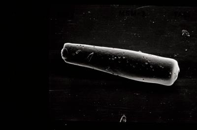
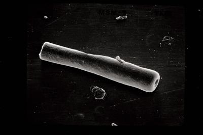
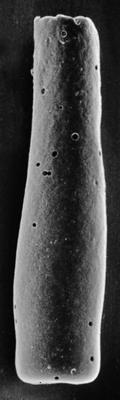
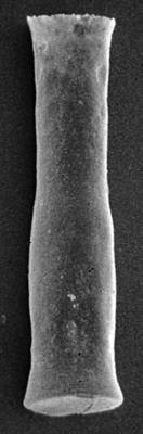
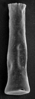
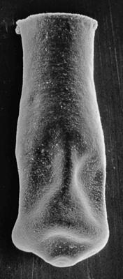
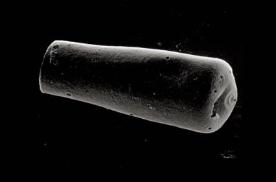
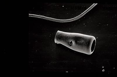
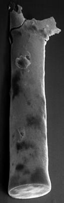
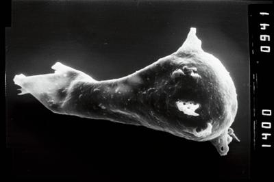
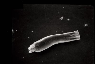
Photos