Localities
... or show all sections
Orjaku borehole
Show additional data in Estonian Geocollections Portal
|
References (3)
Kaljo, D. 1970. Райккюлаский горизонт [Raikküla Stage]. Кальо Д. Л. (ред.) Силур Эстонии [The Silurian of Estonia]. Valgus, Tallinn. 221-232. | DETAILS
Nõlvak, J. 1980. Chitinozoans in biostratigraphy of the northern East Baltic Ashgillian. A preliminary report. Acta Palaeontologica Polonica 25 (2), 253-260. | DETAILS
Nõlvak, J. 1984. Распространение кислотоустойчивых микрофоссилий в разрезах ашгилла Северной Прибалтики [Distribution of acid-resistant microfossils in the northern East Baltic Ashgillian]. Deponeeritud VINITI-sse. 1-70. | DETAILS
Raw data (46 species, 166 samples)
locality	depth	depth_interval	sample_number	Pistillachitina elegans	Conochitina minnesotensis	Cyathochitina kuckersiana	Desmochitina nodosa	Spinachitina cervicornis	Cyathochitina campanulaeformis	Desmochitina juglandiformis	Belonechitina comma	Cyathochitina patagiata	Belonechitina robusta	Clavachitina sp. 1 (oanduensis)	Rhabdochitina sp. 1 (macilenta nom. nud.)	Belonechitina capitata	Belonechitina wesenbergensis brevis	Cyathochitina latipatagium	Fungochitina spinifera	Belonechitina villosa	Cyathochitina angusta	Conochitina incerta	Belonechitina micracantha	Cyathochitina costata	Armoricochitina reticulifera	Calpichitina lata	Lagenochitina baltica	Desmochitina minor s.l.	Calpichitina complanata	Saharochitina fungiformis	Lagenochitina prussica	Angochitina capillata	Lagenochitina cylindrica	Belonechitina wesenbergensis elongata	Conochitina vormsiensis nom. nud.	Rhabdochitina gracilis	Spinachitina coronata	Acanthochitina barbata	Tanuchitina bergstroemi	Rhabdochitina magna	Ancyrochitina ancyrea	Conochitina sp. 3 (lagenoformis)	Conochitina rugata	Plectochitina spongiosa	Conochitina iklaensis	Ancyrochitina bifurcaspina	Euconochitina electa	Belonechitina postrobusta	Belonechitina aspera
Orjaku borehole	6.10	6.15	M-1303			1			-1																																				1
Orjaku borehole	12.90	12.95	M-1305			1			-1																																					1	1	-1
Orjaku borehole	14.10		M-1306			1			-1																																			1			1
Orjaku borehole	14.80		M-1307			1																																									1	1
Orjaku borehole	16.45	16.50	M-1308			1			-1																																								1
Orjaku borehole	17.00		M-1309																																											1	1	1
Orjaku borehole	20.75	20.80	M-1311																																											1
Orjaku borehole	23.00		M-1313
Orjaku borehole	24.60	24.65	M-1314
Orjaku borehole	26.70	26.75	M-1315
Orjaku borehole	27.65	27.69	M-1316
Orjaku borehole	28.55	28.61	M-1317
Orjaku borehole	35.60	35.70	M-9349																																										-1
Orjaku borehole	40.00	40.05	M-9346																																									-1	-1
Orjaku borehole	44.07	44.13	M-13218		1																		1																		1
Orjaku borehole	44.45	44.57	M-4444		1																		1																		1
Orjaku borehole	44.60		M-3111																				1
Orjaku borehole	45.12	45.25	M-13217		1																		1
Orjaku borehole	45.95	46.00	M-13216		1	1																	1					1
Orjaku borehole	46.30	46.35	M-13215		1				1														1
Orjaku borehole	46.60		M-3110		1																		1
Orjaku borehole	46.90	47.00	M-13214		1				1														1									1					1						1
Orjaku borehole	47.52	47.60	M-13213		1																		1																				1
Orjaku borehole	48.30		M-130		1																		1																				1
Orjaku borehole	48.45	48.50	M-13212		1																		1																				1
Orjaku borehole	49.00	49.07	M-13211		1	1																	1					1				1					1					1
Orjaku borehole	49.47	49.55	M-13210		1	1																	1					1				1					1				1
Orjaku borehole	50.40	50.50	M-13209																				1					1				1
Orjaku borehole	51.00		M-3109																				1					1				1
Orjaku borehole	51.20	51.27	M-13208		1	1																	1														1
Orjaku borehole	51.55	51.60	M-13207			1																	1														1			1
Orjaku borehole	52.25	52.32	M-13206		1																		1					1									1			1
Orjaku borehole	52.75	52.82	M-13205																				1					1									1
Orjaku borehole	53.80	53.88	M-13204																				1					1				1					1			1
Orjaku borehole	54.85	54.90	M-13203		1																		1					1				1					1
Orjaku borehole	55.22	55.30	M-13202																									1				1					1
Orjaku borehole	55.90		M-3108		1																		1					1								1	1
Orjaku borehole	56.30		M-196																																	1			1
Orjaku borehole	58.20		M-3107																																	1			1	1
Orjaku borehole	59.00		M-3106																				1													1	1		1	1
Orjaku borehole	60.80		M-3105		1												1						1									1					1
Orjaku borehole	62.50		M-197														1						1					1											1	1	1
Orjaku borehole	63.60		M-3104																																		1			1	1
Orjaku borehole	65.30		M-3103														1						1													1			1	1
Orjaku borehole	67.70		M-131														1						1
Orjaku borehole	70.50	70.60	M-4443														1						1					1								1					1
Orjaku borehole	70.90		M-3102		1												1											1								1					1
Orjaku borehole	72.40		M-3101																				1									1								1
Orjaku borehole	75.00		M-117																				1																1	1
Orjaku borehole	76.00	76.20	M-4442														1					1														1			1	1
Orjaku borehole	77.05	77.25	M-4441																			1					1												1
Orjaku borehole	77.50		M-2111																								1				1								1
Orjaku borehole	78.45		M-3100														1						1				1								1				1
Orjaku borehole	79.00		M-2110														1						1				1				1								1
Orjaku borehole	79.45		M-224																								1
Orjaku borehole	80.34	80.40	M-3099														1					1	1				1	1			1	1				1	1	1	1
Orjaku borehole	81.10		M-225																								1									1	1
Orjaku borehole	81.40	81.65	M-4440																								1									1	1
Orjaku borehole	82.20		M-2115																								1				1
Orjaku borehole	82.70		M-3098			1																	1				1	1								1	1	1
Orjaku borehole	83.10		M-2114			1																					1								1		1
Orjaku borehole	84.00		M-3097			1																					1				1				1		1
Orjaku borehole	84.70		M-3096			1																1	1					1							1		1	1
Orjaku borehole	85.10		M-2109			1																1													1
Orjaku borehole	86.00		M-118			1
Orjaku borehole	86.50		M-3095			1																	1				1							1	1	1	1
Orjaku borehole	86.90		M-3094			1																1	1								1				1
Orjaku borehole	88.00		M-3093			1																													1	1
Orjaku borehole	88.50		M-3092			1																									1			1	1		1
Orjaku borehole	89.10		M-3091																				1				1				1				1
Orjaku borehole	89.60		M-125																				1				1				1			1	1	1
Orjaku borehole	89.90		M-3090																			1					1			1	1		1	1	1	1	1
Orjaku borehole	90.60		M-3089																			1	1				1							1	1
Orjaku borehole	91.10		M-3088			1											1					1	1				1				1				1	1	1
Orjaku borehole	91.50	91.50	M-4439			1																1					1							1	1	1
Orjaku borehole	91.85		M-3087																			1	1								1	1		1	1	1
Orjaku borehole	92.80		M-3086			1																1	1				1						1	1
Orjaku borehole	93.80		M-133																			1	1											1
Orjaku borehole	94.80		M-3085																				1				1							1
Orjaku borehole	95.40		M-3084																			1	1											1
Orjaku borehole	95.90		M-3083			1											1					1	1
Orjaku borehole	96.60		M-3082		1				1													1	1				1	1
Orjaku borehole	97.10		M-120						1													1					1							1
Orjaku borehole	97.60		M-3081														1					1										1		1
Orjaku borehole	98.00	98.30	M-4438						1														1				1						1	1
Orjaku borehole	98.20		M-134						1								1						1				1
Orjaku borehole	98.85		M-3080						1								1					1	1				1	1	1	1	1	1
Orjaku borehole	99.40		M-3079			1			1								1					1					1	1
Orjaku borehole	99.90		M-3078						1																			1
Orjaku borehole	101.30		M-119						1								1					1
Orjaku borehole	102.00		M-3077						1								1					1						1
Orjaku borehole	102.50		M-3076						1								1					1			1		1
Orjaku borehole	103.00		M-3075						1		1						1
Orjaku borehole	103.50		M-126						1								1								1		1
Orjaku borehole	103.73	103.80	M-3074						1														1		1		1
Orjaku borehole	104.00		M-3073						1		1				1		1			1		1	1		1
Orjaku borehole	104.40		M-3072						1			1					1					1			1	1
Orjaku borehole	104.80		M-3071			1			1								1						1	1	1	1
Orjaku borehole	105.40		M-3070			1					1						1							1	1
Orjaku borehole	105.80	105.90	M-135			1			1		1						1						1
Orjaku borehole	106.70		M-3068		1	1							1				1
Orjaku borehole	107.40		M-123		1								1				1
Orjaku borehole	107.90		M-121								1						1
Orjaku borehole	108.40	108.70	M-4410		1				1		1		1		1		1
Orjaku borehole	108.90		M-3067						1								1						1
Orjaku borehole	109.50		M-3066						1				1				1					1
Orjaku borehole	109.80		M-3065						1		1		1				1				1
Orjaku borehole	110.30		M-3064		1				1		1		1				1
Orjaku borehole	111.70		M-3063										1
Orjaku borehole	112.40		M-3062						1				1				1
Orjaku borehole	113.40		M-3061		1							1	1				1				1
Orjaku borehole	114.40		M-3060									1	1				1		1
Orjaku borehole	115.50		M-3059		1								1				1		1
Orjaku borehole	116.60		M-3058		1								1		1						1
Orjaku borehole	117.20		M-3057										1								1
Orjaku borehole	118.00		M-3056		1								1		1						1
Orjaku borehole	118.90		M-3055									1	1		1		1				1
Orjaku borehole	119.90		M-3054									1	1						1
Orjaku borehole	121.10		M-3053		1							1					1		1		1
Orjaku borehole	122.10		M-3052										1
Orjaku borehole	123.40		M-3051										1				1
Orjaku borehole	123.95	124.06	M-4435		1								1				1
Orjaku borehole	124.90		M-3050		1				1				1
Orjaku borehole	126.00		M-3049		1				1				1				1
Orjaku borehole	127.10		M-3048		1								1
Orjaku borehole	128.20		M-3047										1				1
Orjaku borehole	129.05		M-3046		1								1
Orjaku borehole	129.50		M-3045						1				1						1
Orjaku borehole	129.70		M-3044						1				1		1		1
Orjaku borehole	129.95	129.95	M-3043		1				1				1	1	1				1	1
Orjaku borehole	130.35	130.35	M-220		1			1	1				1		1			1
Orjaku borehole	130.70	130.70	M-3042		1				1					1	1		1
Orjaku borehole	131.00		M-219					1	1				1		1	1
Orjaku borehole	131.50		M-218		1	1			1			1		1	1
Orjaku borehole	131.73	131.73	M-4435		1	1						1		1
Orjaku borehole	132.00		M-217		1							1
Orjaku borehole	132.40		M-216		1	1		1	1				1
Orjaku borehole	132.60	132.60	M-3036		1			1	1			1
Orjaku borehole	133.00		M-3035	1		1
Orjaku borehole	133.30	133.36	M-4915		1	1	1
Orjaku borehole	133.62	133.69	M-4433	1		1	1			1
Orjaku borehole	134.00		M-3033	1	1	1			1	1
Orjaku borehole	134.50		M-3032	1					1
Orjaku borehole	135.00		M-3031		1	1
Orjaku borehole	135.14	135.17	M-4431		1	1
Orjaku borehole	135.60	135.65	M-4430	1	1	1	1		1
Orjaku borehole	135.85		M-3024		1	1
Orjaku borehole	136.18	136.22	M-4426		1	1	1
Orjaku borehole	136.59	136.60	M-4425		1	1	1
Orjaku borehole	136.60	136.63	M-4424	1	1	1	1		1
Orjaku borehole	137.00		M-3028		1	1				1
Orjaku borehole	137.20	137.20	M-4913		1	1	1			1	1
Orjaku borehole	137.40		M-3027	1	1	1
Orjaku borehole	137.70	137.70	M-4912	1		1	1
Orjaku borehole	137.90		M-3026	1	1	1
Orjaku borehole	138.15	138.22	M-4910	1		1
Orjaku borehole	138.40		M-4909	1	1	1
Orjaku borehole	138.59	138.65	M-4908	1		1
Orjaku borehole	138.80		M-4907	1		1
Orjaku borehole	139.07	139.14	M-4906			1	1		1
Orjaku borehole	139.55	139.60	M-4905	1	1	1	1	1	1
Orjaku borehole	139.87	140.00	M-4422		1	1
Orjaku borehole	140.45	140.50	M-4904	1		1	1
Orjaku borehole	141.00		M-4903	1	1	1	1
Orjaku borehole	141.40		M-4902	1	1	1
Orjaku borehole	141.80		M-3025	1	1	1
| locality | depth | depth_interval | sample_number | Pistillachitina elegans | Conochitina minnesotensis | Cyathochitina kuckersiana | Desmochitina nodosa | Spinachitina cervicornis | Cyathochitina campanulaeformis | Desmochitina juglandiformis | Belonechitina comma | Cyathochitina patagiata | Belonechitina robusta | Clavachitina sp. 1 (oanduensis) | Rhabdochitina sp. 1 (macilenta nom. nud.) | Belonechitina capitata | Belonechitina wesenbergensis brevis | Cyathochitina latipatagium | Fungochitina spinifera | Belonechitina villosa | Cyathochitina angusta | Conochitina incerta | Belonechitina micracantha | Cyathochitina costata | Armoricochitina reticulifera | Calpichitina lata | Lagenochitina baltica | Desmochitina minor s.l. | Calpichitina complanata | Saharochitina fungiformis | Lagenochitina prussica | Angochitina capillata | Lagenochitina cylindrica | Belonechitina wesenbergensis elongata | Conochitina vormsiensis nom. nud. | Rhabdochitina gracilis | Spinachitina coronata | Acanthochitina barbata | Tanuchitina bergstroemi | Rhabdochitina magna | Ancyrochitina ancyrea | Conochitina sp. 3 (lagenoformis) | Conochitina rugata | Plectochitina spongiosa | Conochitina iklaensis | Ancyrochitina bifurcaspina | Euconochitina electa | Belonechitina postrobusta | Belonechitina aspera |
|---|---|---|---|---|---|---|---|---|---|---|---|---|---|---|---|---|---|---|---|---|---|---|---|---|---|---|---|---|---|---|---|---|---|---|---|---|---|---|---|---|---|---|---|---|---|---|---|---|---|
| Orjaku borehole | 6.10 | 6.15 | M-1303 | 1 | -1 | 1 | |||||||||||||||||||||||||||||||||||||||||||
| Orjaku borehole | 12.90 | 12.95 | M-1305 | 1 | -1 | 1 | 1 | -1 | |||||||||||||||||||||||||||||||||||||||||
| Orjaku borehole | 14.10 | M-1306 | 1 | -1 | 1 | 1 | |||||||||||||||||||||||||||||||||||||||||||
| Orjaku borehole | 14.80 | M-1307 | 1 | 1 | 1 | ||||||||||||||||||||||||||||||||||||||||||||
| Orjaku borehole | 16.45 | 16.50 | M-1308 | 1 | -1 | 1 | |||||||||||||||||||||||||||||||||||||||||||
| Orjaku borehole | 17.00 | M-1309 | 1 | 1 | 1 | ||||||||||||||||||||||||||||||||||||||||||||
| Orjaku borehole | 20.75 | 20.80 | M-1311 | 1 | |||||||||||||||||||||||||||||||||||||||||||||
| Orjaku borehole | 23.00 | M-1313 | |||||||||||||||||||||||||||||||||||||||||||||||
| Orjaku borehole | 24.60 | 24.65 | M-1314 | ||||||||||||||||||||||||||||||||||||||||||||||
| Orjaku borehole | 26.70 | 26.75 | M-1315 | ||||||||||||||||||||||||||||||||||||||||||||||
| Orjaku borehole | 27.65 | 27.69 | M-1316 | ||||||||||||||||||||||||||||||||||||||||||||||
| Orjaku borehole | 28.55 | 28.61 | M-1317 | ||||||||||||||||||||||||||||||||||||||||||||||
| Orjaku borehole | 35.60 | 35.70 | M-9349 | -1 | |||||||||||||||||||||||||||||||||||||||||||||
| Orjaku borehole | 40.00 | 40.05 | M-9346 | -1 | -1 | ||||||||||||||||||||||||||||||||||||||||||||
| Orjaku borehole | 44.07 | 44.13 | M-13218 | 1 | 1 | 1 | |||||||||||||||||||||||||||||||||||||||||||
| Orjaku borehole | 44.45 | 44.57 | M-4444 | 1 | 1 | 1 | |||||||||||||||||||||||||||||||||||||||||||
| Orjaku borehole | 44.60 | M-3111 | 1 | ||||||||||||||||||||||||||||||||||||||||||||||
| Orjaku borehole | 45.12 | 45.25 | M-13217 | 1 | 1 | ||||||||||||||||||||||||||||||||||||||||||||
| Orjaku borehole | 45.95 | 46.00 | M-13216 | 1 | 1 | 1 | 1 | ||||||||||||||||||||||||||||||||||||||||||
| Orjaku borehole | 46.30 | 46.35 | M-13215 | 1 | 1 | 1 | |||||||||||||||||||||||||||||||||||||||||||
| Orjaku borehole | 46.60 | M-3110 | 1 | 1 | |||||||||||||||||||||||||||||||||||||||||||||
| Orjaku borehole | 46.90 | 47.00 | M-13214 | 1 | 1 | 1 | 1 | 1 | 1 | ||||||||||||||||||||||||||||||||||||||||
| Orjaku borehole | 47.52 | 47.60 | M-13213 | 1 | 1 | 1 | |||||||||||||||||||||||||||||||||||||||||||
| Orjaku borehole | 48.30 | M-130 | 1 | 1 | 1 | ||||||||||||||||||||||||||||||||||||||||||||
| Orjaku borehole | 48.45 | 48.50 | M-13212 | 1 | 1 | 1 | |||||||||||||||||||||||||||||||||||||||||||
| Orjaku borehole | 49.00 | 49.07 | M-13211 | 1 | 1 | 1 | 1 | 1 | 1 | 1 | |||||||||||||||||||||||||||||||||||||||
| Orjaku borehole | 49.47 | 49.55 | M-13210 | 1 | 1 | 1 | 1 | 1 | 1 | 1 | |||||||||||||||||||||||||||||||||||||||
| Orjaku borehole | 50.40 | 50.50 | M-13209 | 1 | 1 | 1 | |||||||||||||||||||||||||||||||||||||||||||
| Orjaku borehole | 51.00 | M-3109 | 1 | 1 | 1 | ||||||||||||||||||||||||||||||||||||||||||||
| Orjaku borehole | 51.20 | 51.27 | M-13208 | 1 | 1 | 1 | 1 | ||||||||||||||||||||||||||||||||||||||||||
| Orjaku borehole | 51.55 | 51.60 | M-13207 | 1 | 1 | 1 | 1 | ||||||||||||||||||||||||||||||||||||||||||
| Orjaku borehole | 52.25 | 52.32 | M-13206 | 1 | 1 | 1 | 1 | 1 | |||||||||||||||||||||||||||||||||||||||||
| Orjaku borehole | 52.75 | 52.82 | M-13205 | 1 | 1 | 1 | |||||||||||||||||||||||||||||||||||||||||||
| Orjaku borehole | 53.80 | 53.88 | M-13204 | 1 | 1 | 1 | 1 | 1 | |||||||||||||||||||||||||||||||||||||||||
| Orjaku borehole | 54.85 | 54.90 | M-13203 | 1 | 1 | 1 | 1 | 1 | |||||||||||||||||||||||||||||||||||||||||
| Orjaku borehole | 55.22 | 55.30 | M-13202 | 1 | 1 | 1 | |||||||||||||||||||||||||||||||||||||||||||
| Orjaku borehole | 55.90 | M-3108 | 1 | 1 | 1 | 1 | 1 | ||||||||||||||||||||||||||||||||||||||||||
| Orjaku borehole | 56.30 | M-196 | 1 | 1 | |||||||||||||||||||||||||||||||||||||||||||||
| Orjaku borehole | 58.20 | M-3107 | 1 | 1 | 1 | ||||||||||||||||||||||||||||||||||||||||||||
| Orjaku borehole | 59.00 | M-3106 | 1 | 1 | 1 | 1 | 1 | ||||||||||||||||||||||||||||||||||||||||||
| Orjaku borehole | 60.80 | M-3105 | 1 | 1 | 1 | 1 | 1 | ||||||||||||||||||||||||||||||||||||||||||
| Orjaku borehole | 62.50 | M-197 | 1 | 1 | 1 | 1 | 1 | 1 | |||||||||||||||||||||||||||||||||||||||||
| Orjaku borehole | 63.60 | M-3104 | 1 | 1 | 1 | ||||||||||||||||||||||||||||||||||||||||||||
| Orjaku borehole | 65.30 | M-3103 | 1 | 1 | 1 | 1 | 1 | ||||||||||||||||||||||||||||||||||||||||||
| Orjaku borehole | 67.70 | M-131 | 1 | 1 | |||||||||||||||||||||||||||||||||||||||||||||
| Orjaku borehole | 70.50 | 70.60 | M-4443 | 1 | 1 | 1 | 1 | 1 | |||||||||||||||||||||||||||||||||||||||||
| Orjaku borehole | 70.90 | M-3102 | 1 | 1 | 1 | 1 | 1 | ||||||||||||||||||||||||||||||||||||||||||
| Orjaku borehole | 72.40 | M-3101 | 1 | 1 | 1 | ||||||||||||||||||||||||||||||||||||||||||||
| Orjaku borehole | 75.00 | M-117 | 1 | 1 | 1 | ||||||||||||||||||||||||||||||||||||||||||||
| Orjaku borehole | 76.00 | 76.20 | M-4442 | 1 | 1 | 1 | 1 | 1 | |||||||||||||||||||||||||||||||||||||||||
| Orjaku borehole | 77.05 | 77.25 | M-4441 | 1 | 1 | 1 | |||||||||||||||||||||||||||||||||||||||||||
| Orjaku borehole | 77.50 | M-2111 | 1 | 1 | 1 | ||||||||||||||||||||||||||||||||||||||||||||
| Orjaku borehole | 78.45 | M-3100 | 1 | 1 | 1 | 1 | 1 | ||||||||||||||||||||||||||||||||||||||||||
| Orjaku borehole | 79.00 | M-2110 | 1 | 1 | 1 | 1 | 1 | ||||||||||||||||||||||||||||||||||||||||||
| Orjaku borehole | 79.45 | M-224 | 1 | ||||||||||||||||||||||||||||||||||||||||||||||
| Orjaku borehole | 80.34 | 80.40 | M-3099 | 1 | 1 | 1 | 1 | 1 | 1 | 1 | 1 | 1 | 1 | 1 | |||||||||||||||||||||||||||||||||||
| Orjaku borehole | 81.10 | M-225 | 1 | 1 | 1 | ||||||||||||||||||||||||||||||||||||||||||||
| Orjaku borehole | 81.40 | 81.65 | M-4440 | 1 | 1 | 1 | |||||||||||||||||||||||||||||||||||||||||||
| Orjaku borehole | 82.20 | M-2115 | 1 | 1 | |||||||||||||||||||||||||||||||||||||||||||||
| Orjaku borehole | 82.70 | M-3098 | 1 | 1 | 1 | 1 | 1 | 1 | 1 | ||||||||||||||||||||||||||||||||||||||||
| Orjaku borehole | 83.10 | M-2114 | 1 | 1 | 1 | 1 | |||||||||||||||||||||||||||||||||||||||||||
| Orjaku borehole | 84.00 | M-3097 | 1 | 1 | 1 | 1 | 1 | ||||||||||||||||||||||||||||||||||||||||||
| Orjaku borehole | 84.70 | M-3096 | 1 | 1 | 1 | 1 | 1 | 1 | 1 | ||||||||||||||||||||||||||||||||||||||||
| Orjaku borehole | 85.10 | M-2109 | 1 | 1 | 1 | ||||||||||||||||||||||||||||||||||||||||||||
| Orjaku borehole | 86.00 | M-118 | 1 | ||||||||||||||||||||||||||||||||||||||||||||||
| Orjaku borehole | 86.50 | M-3095 | 1 | 1 | 1 | 1 | 1 | 1 | 1 | ||||||||||||||||||||||||||||||||||||||||
| Orjaku borehole | 86.90 | M-3094 | 1 | 1 | 1 | 1 | 1 | ||||||||||||||||||||||||||||||||||||||||||
| Orjaku borehole | 88.00 | M-3093 | 1 | 1 | 1 | ||||||||||||||||||||||||||||||||||||||||||||
| Orjaku borehole | 88.50 | M-3092 | 1 | 1 | 1 | 1 | 1 | ||||||||||||||||||||||||||||||||||||||||||
| Orjaku borehole | 89.10 | M-3091 | 1 | 1 | 1 | 1 | |||||||||||||||||||||||||||||||||||||||||||
| Orjaku borehole | 89.60 | M-125 | 1 | 1 | 1 | 1 | 1 | 1 | |||||||||||||||||||||||||||||||||||||||||
| Orjaku borehole | 89.90 | M-3090 | 1 | 1 | 1 | 1 | 1 | 1 | 1 | 1 | 1 | ||||||||||||||||||||||||||||||||||||||
| Orjaku borehole | 90.60 | M-3089 | 1 | 1 | 1 | 1 | 1 | ||||||||||||||||||||||||||||||||||||||||||
| Orjaku borehole | 91.10 | M-3088 | 1 | 1 | 1 | 1 | 1 | 1 | 1 | 1 | 1 | ||||||||||||||||||||||||||||||||||||||
| Orjaku borehole | 91.50 | 91.50 | M-4439 | 1 | 1 | 1 | 1 | 1 | 1 | ||||||||||||||||||||||||||||||||||||||||
| Orjaku borehole | 91.85 | M-3087 | 1 | 1 | 1 | 1 | 1 | 1 | 1 | ||||||||||||||||||||||||||||||||||||||||
| Orjaku borehole | 92.80 | M-3086 | 1 | 1 | 1 | 1 | 1 | 1 | |||||||||||||||||||||||||||||||||||||||||
| Orjaku borehole | 93.80 | M-133 | 1 | 1 | 1 | ||||||||||||||||||||||||||||||||||||||||||||
| Orjaku borehole | 94.80 | M-3085 | 1 | 1 | 1 | ||||||||||||||||||||||||||||||||||||||||||||
| Orjaku borehole | 95.40 | M-3084 | 1 | 1 | 1 | ||||||||||||||||||||||||||||||||||||||||||||
| Orjaku borehole | 95.90 | M-3083 | 1 | 1 | 1 | 1 | |||||||||||||||||||||||||||||||||||||||||||
| Orjaku borehole | 96.60 | M-3082 | 1 | 1 | 1 | 1 | 1 | 1 | |||||||||||||||||||||||||||||||||||||||||
| Orjaku borehole | 97.10 | M-120 | 1 | 1 | 1 | 1 | |||||||||||||||||||||||||||||||||||||||||||
| Orjaku borehole | 97.60 | M-3081 | 1 | 1 | 1 | 1 | |||||||||||||||||||||||||||||||||||||||||||
| Orjaku borehole | 98.00 | 98.30 | M-4438 | 1 | 1 | 1 | 1 | 1 | |||||||||||||||||||||||||||||||||||||||||
| Orjaku borehole | 98.20 | M-134 | 1 | 1 | 1 | 1 | |||||||||||||||||||||||||||||||||||||||||||
| Orjaku borehole | 98.85 | M-3080 | 1 | 1 | 1 | 1 | 1 | 1 | 1 | 1 | 1 | 1 | |||||||||||||||||||||||||||||||||||||
| Orjaku borehole | 99.40 | M-3079 | 1 | 1 | 1 | 1 | 1 | 1 | |||||||||||||||||||||||||||||||||||||||||
| Orjaku borehole | 99.90 | M-3078 | 1 | 1 | |||||||||||||||||||||||||||||||||||||||||||||
| Orjaku borehole | 101.30 | M-119 | 1 | 1 | 1 | ||||||||||||||||||||||||||||||||||||||||||||
| Orjaku borehole | 102.00 | M-3077 | 1 | 1 | 1 | 1 | |||||||||||||||||||||||||||||||||||||||||||
| Orjaku borehole | 102.50 | M-3076 | 1 | 1 | 1 | 1 | 1 | ||||||||||||||||||||||||||||||||||||||||||
| Orjaku borehole | 103.00 | M-3075 | 1 | 1 | 1 | ||||||||||||||||||||||||||||||||||||||||||||
| Orjaku borehole | 103.50 | M-126 | 1 | 1 | 1 | 1 | |||||||||||||||||||||||||||||||||||||||||||
| Orjaku borehole | 103.73 | 103.80 | M-3074 | 1 | 1 | 1 | 1 | ||||||||||||||||||||||||||||||||||||||||||
| Orjaku borehole | 104.00 | M-3073 | 1 | 1 | 1 | 1 | 1 | 1 | 1 | 1 | |||||||||||||||||||||||||||||||||||||||
| Orjaku borehole | 104.40 | M-3072 | 1 | 1 | 1 | 1 | 1 | 1 | |||||||||||||||||||||||||||||||||||||||||
| Orjaku borehole | 104.80 | M-3071 | 1 | 1 | 1 | 1 | 1 | 1 | 1 | ||||||||||||||||||||||||||||||||||||||||
| Orjaku borehole | 105.40 | M-3070 | 1 | 1 | 1 | 1 | 1 | ||||||||||||||||||||||||||||||||||||||||||
| Orjaku borehole | 105.80 | 105.90 | M-135 | 1 | 1 | 1 | 1 | 1 | |||||||||||||||||||||||||||||||||||||||||
| Orjaku borehole | 106.70 | M-3068 | 1 | 1 | 1 | 1 | |||||||||||||||||||||||||||||||||||||||||||
| Orjaku borehole | 107.40 | M-123 | 1 | 1 | 1 | ||||||||||||||||||||||||||||||||||||||||||||
| Orjaku borehole | 107.90 | M-121 | 1 | 1 | |||||||||||||||||||||||||||||||||||||||||||||
| Orjaku borehole | 108.40 | 108.70 | M-4410 | 1 | 1 | 1 | 1 | 1 | 1 | ||||||||||||||||||||||||||||||||||||||||
| Orjaku borehole | 108.90 | M-3067 | 1 | 1 | 1 | ||||||||||||||||||||||||||||||||||||||||||||
| Orjaku borehole | 109.50 | M-3066 | 1 | 1 | 1 | 1 | |||||||||||||||||||||||||||||||||||||||||||
| Orjaku borehole | 109.80 | M-3065 | 1 | 1 | 1 | 1 | 1 | ||||||||||||||||||||||||||||||||||||||||||
| Orjaku borehole | 110.30 | M-3064 | 1 | 1 | 1 | 1 | 1 | ||||||||||||||||||||||||||||||||||||||||||
| Orjaku borehole | 111.70 | M-3063 | 1 | ||||||||||||||||||||||||||||||||||||||||||||||
| Orjaku borehole | 112.40 | M-3062 | 1 | 1 | 1 | ||||||||||||||||||||||||||||||||||||||||||||
| Orjaku borehole | 113.40 | M-3061 | 1 | 1 | 1 | 1 | 1 | ||||||||||||||||||||||||||||||||||||||||||
| Orjaku borehole | 114.40 | M-3060 | 1 | 1 | 1 | 1 | |||||||||||||||||||||||||||||||||||||||||||
| Orjaku borehole | 115.50 | M-3059 | 1 | 1 | 1 | 1 | |||||||||||||||||||||||||||||||||||||||||||
| Orjaku borehole | 116.60 | M-3058 | 1 | 1 | 1 | 1 | |||||||||||||||||||||||||||||||||||||||||||
| Orjaku borehole | 117.20 | M-3057 | 1 | 1 | |||||||||||||||||||||||||||||||||||||||||||||
| Orjaku borehole | 118.00 | M-3056 | 1 | 1 | 1 | 1 | |||||||||||||||||||||||||||||||||||||||||||
| Orjaku borehole | 118.90 | M-3055 | 1 | 1 | 1 | 1 | 1 | ||||||||||||||||||||||||||||||||||||||||||
| Orjaku borehole | 119.90 | M-3054 | 1 | 1 | 1 | ||||||||||||||||||||||||||||||||||||||||||||
| Orjaku borehole | 121.10 | M-3053 | 1 | 1 | 1 | 1 | 1 | ||||||||||||||||||||||||||||||||||||||||||
| Orjaku borehole | 122.10 | M-3052 | 1 | ||||||||||||||||||||||||||||||||||||||||||||||
| Orjaku borehole | 123.40 | M-3051 | 1 | 1 | |||||||||||||||||||||||||||||||||||||||||||||
| Orjaku borehole | 123.95 | 124.06 | M-4435 | 1 | 1 | 1 | |||||||||||||||||||||||||||||||||||||||||||
| Orjaku borehole | 124.90 | M-3050 | 1 | 1 | 1 | ||||||||||||||||||||||||||||||||||||||||||||
| Orjaku borehole | 126.00 | M-3049 | 1 | 1 | 1 | 1 | |||||||||||||||||||||||||||||||||||||||||||
| Orjaku borehole | 127.10 | M-3048 | 1 | 1 | |||||||||||||||||||||||||||||||||||||||||||||
| Orjaku borehole | 128.20 | M-3047 | 1 | 1 | |||||||||||||||||||||||||||||||||||||||||||||
| Orjaku borehole | 129.05 | M-3046 | 1 | 1 | |||||||||||||||||||||||||||||||||||||||||||||
| Orjaku borehole | 129.50 | M-3045 | 1 | 1 | 1 | ||||||||||||||||||||||||||||||||||||||||||||
| Orjaku borehole | 129.70 | M-3044 | 1 | 1 | 1 | 1 | |||||||||||||||||||||||||||||||||||||||||||
| Orjaku borehole | 129.95 | 129.95 | M-3043 | 1 | 1 | 1 | 1 | 1 | 1 | 1 | |||||||||||||||||||||||||||||||||||||||
| Orjaku borehole | 130.35 | 130.35 | M-220 | 1 | 1 | 1 | 1 | 1 | 1 | ||||||||||||||||||||||||||||||||||||||||
| Orjaku borehole | 130.70 | 130.70 | M-3042 | 1 | 1 | 1 | 1 | 1 | |||||||||||||||||||||||||||||||||||||||||
| Orjaku borehole | 131.00 | M-219 | 1 | 1 | 1 | 1 | 1 | ||||||||||||||||||||||||||||||||||||||||||
| Orjaku borehole | 131.50 | M-218 | 1 | 1 | 1 | 1 | 1 | 1 | |||||||||||||||||||||||||||||||||||||||||
| Orjaku borehole | 131.73 | 131.73 | M-4435 | 1 | 1 | 1 | 1 | ||||||||||||||||||||||||||||||||||||||||||
| Orjaku borehole | 132.00 | M-217 | 1 | 1 | |||||||||||||||||||||||||||||||||||||||||||||
| Orjaku borehole | 132.40 | M-216 | 1 | 1 | 1 | 1 | 1 | ||||||||||||||||||||||||||||||||||||||||||
| Orjaku borehole | 132.60 | 132.60 | M-3036 | 1 | 1 | 1 | 1 | ||||||||||||||||||||||||||||||||||||||||||
| Orjaku borehole | 133.00 | M-3035 | 1 | 1 | |||||||||||||||||||||||||||||||||||||||||||||
| Orjaku borehole | 133.30 | 133.36 | M-4915 | 1 | 1 | 1 | |||||||||||||||||||||||||||||||||||||||||||
| Orjaku borehole | 133.62 | 133.69 | M-4433 | 1 | 1 | 1 | 1 | ||||||||||||||||||||||||||||||||||||||||||
| Orjaku borehole | 134.00 | M-3033 | 1 | 1 | 1 | 1 | 1 | ||||||||||||||||||||||||||||||||||||||||||
| Orjaku borehole | 134.50 | M-3032 | 1 | 1 | |||||||||||||||||||||||||||||||||||||||||||||
| Orjaku borehole | 135.00 | M-3031 | 1 | 1 | |||||||||||||||||||||||||||||||||||||||||||||
| Orjaku borehole | 135.14 | 135.17 | M-4431 | 1 | 1 | ||||||||||||||||||||||||||||||||||||||||||||
| Orjaku borehole | 135.60 | 135.65 | M-4430 | 1 | 1 | 1 | 1 | 1 | |||||||||||||||||||||||||||||||||||||||||
| Orjaku borehole | 135.85 | M-3024 | 1 | 1 | |||||||||||||||||||||||||||||||||||||||||||||
| Orjaku borehole | 136.18 | 136.22 | M-4426 | 1 | 1 | 1 | |||||||||||||||||||||||||||||||||||||||||||
| Orjaku borehole | 136.59 | 136.60 | M-4425 | 1 | 1 | 1 | |||||||||||||||||||||||||||||||||||||||||||
| Orjaku borehole | 136.60 | 136.63 | M-4424 | 1 | 1 | 1 | 1 | 1 | |||||||||||||||||||||||||||||||||||||||||
| Orjaku borehole | 137.00 | M-3028 | 1 | 1 | 1 | ||||||||||||||||||||||||||||||||||||||||||||
| Orjaku borehole | 137.20 | 137.20 | M-4913 | 1 | 1 | 1 | 1 | 1 | |||||||||||||||||||||||||||||||||||||||||
| Orjaku borehole | 137.40 | M-3027 | 1 | 1 | 1 | ||||||||||||||||||||||||||||||||||||||||||||
| Orjaku borehole | 137.70 | 137.70 | M-4912 | 1 | 1 | 1 | |||||||||||||||||||||||||||||||||||||||||||
| Orjaku borehole | 137.90 | M-3026 | 1 | 1 | 1 | ||||||||||||||||||||||||||||||||||||||||||||
| Orjaku borehole | 138.15 | 138.22 | M-4910 | 1 | 1 | ||||||||||||||||||||||||||||||||||||||||||||
| Orjaku borehole | 138.40 | M-4909 | 1 | 1 | 1 | ||||||||||||||||||||||||||||||||||||||||||||
| Orjaku borehole | 138.59 | 138.65 | M-4908 | 1 | 1 | ||||||||||||||||||||||||||||||||||||||||||||
| Orjaku borehole | 138.80 | M-4907 | 1 | 1 | |||||||||||||||||||||||||||||||||||||||||||||
| Orjaku borehole | 139.07 | 139.14 | M-4906 | 1 | 1 | 1 | |||||||||||||||||||||||||||||||||||||||||||
| Orjaku borehole | 139.55 | 139.60 | M-4905 | 1 | 1 | 1 | 1 | 1 | 1 | ||||||||||||||||||||||||||||||||||||||||
| Orjaku borehole | 139.87 | 140.00 | M-4422 | 1 | 1 | ||||||||||||||||||||||||||||||||||||||||||||
| Orjaku borehole | 140.45 | 140.50 | M-4904 | 1 | 1 | 1 | |||||||||||||||||||||||||||||||||||||||||||
| Orjaku borehole | 141.00 | M-4903 | 1 | 1 | 1 | 1 | |||||||||||||||||||||||||||||||||||||||||||
| Orjaku borehole | 141.40 | M-4902 | 1 | 1 | 1 | ||||||||||||||||||||||||||||||||||||||||||||
| Orjaku borehole | 141.80 | M-3025 | 1 | 1 | 1 |
Show table
Range chart (autogenerated)
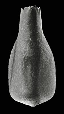
Photos
Tooltip: to show larger image hold Ctrl-key when clicking on image.