Localities
... or show all sections
Staicele 4 borehole
Show additional data in Estonian Geocollections Portal
|
References (1)
Raw data (55 species, 141 samples)
locality	depth	depth_interval	sample_number	Spinachitina fragilis	Cyathochitina campanulaeformis	Belonechitina postrobusta	Plectochitina spongiosa	Cyathochitina calix	Belonechitina aspera	Euconochitina electa	Cyathochitina kuckersiana	Conochitina iklaensis	Ancyrochitina bifurcaspina	Plectochitina nodifera	Spinachitina maennili	Conochitina edjelensis	Ancyrochitina convexa	Conochitina elongata	Conochitina alargada	Conochitina malleus	Rhabdochitina sp. 2 (Nestor et al., 2003)	Conochitina rara	Conochitina praeproboscifera	Conochitina leviscapulae	Belonechitina cavei	Belonechitina oeselensis	Conochitina emmastensis	Bursachitina conica	Ancyrochitina rumbaensis	Eisenackitina causiata 	Bursachitina nestorae	Eisenackitina dolioliformis	Calpichitina densa	Ancyrochitina ansarviensis	Conochitina mamilla	Plectochitina pachyderma	Conochitina claviformis	Margachitina margaritana	Conochitina leptosoma	Conochitina tuba	Calpichitina acollaris	Bursachitina sp. B (Loydell et al., 2009)	Conochitina armillata	Ancyrochitina paulaspina	Ramochitina martinssoni	Ancyrochitina clathrospinosa	Ramochitina uncinata	Cingulochitina cingulata	Ancyrochitina gutnica	Ancyrochitina plurispinosa	Conochitina argillophila	Cingulochitina crassa	Cingulochitina baltica	Eisenackitina spongiosa	Conochitina postproboscifera nom. nud.	Conochitina pachycephala	Linochitina odiosa	Conochitina subcyatha
Staicele 4 borehole	244.40	244.50	M-11869																																								1	1				1		1		1	1			1	1	-1
Staicele 4 borehole	245.40	245.50	M-11868																																		1		1	1								1					1				1
Staicele 4 borehole	246.40	246.50	M-11867																																	1	1		1	1				1				1	1	1			1		1	1	1
Staicele 4 borehole	247.80	247.90	M-11866																																		1	1		1				1				1						1
Staicele 4 borehole	249.00	249.10	M-11865																																		1	1		1							1	1		1		1	1	1
Staicele 4 borehole	250.00	250.10	M-11864																																	1	1	1		1			1					1			1		1
Staicele 4 borehole	251.40	251.50	M-11863																																	1		1		1			1					1		1	1	1
Staicele 4 borehole	252.30	252.40	M-11862																																	1				1				1				1		1	1	1
Staicele 4 borehole	254.30	254.40	M-11861																																	1	1	1		1						1		1		1
Staicele 4 borehole	256.40	256.50	M-11860																																	1	1	1		1			1	1			1		1	1
Staicele 4 borehole	258.30	258.40	M-11859																																	1	1	1		1				1				1		1
Staicele 4 borehole	260.00	260.10	M-11858																																	1	1	1		1			1
Staicele 4 borehole	262.40	262.50	M-10895																																	1	1			1			1	1
Staicele 4 borehole	264.20	264.30	M-11857																																	1	1	1		1			1	1	1		-1	1	1
Staicele 4 borehole	266.20	266.30	M-11856																																	1	1	1		1			1		1	1	-1	1
Staicele 4 borehole	268.10	268.20	M-11855																																	1	1	1					1
Staicele 4 borehole	270.10	270.20	M-11854																																	1	1	1		1	1		1	1
Staicele 4 borehole	271.50	271.60	M-11853																																		1	1			1			1
Staicele 4 borehole	273.00	273.10	M-11852																																	1	1	1		1	1
Staicele 4 borehole	274.50	274.60	M-11851																																	1	1	1		1	1	1	1
Staicele 4 borehole	275.40	275.50	M-11850																																	1	1	1		1	1	1
Staicele 4 borehole	276.60	276.70	M-11849																																	1	1	1			1
Staicele 4 borehole	278.50	278.60	M-11848																																		1	1	1		1
Staicele 4 borehole	280.30	280.40	M-10943																																1		1	1	1	1
Staicele 4 borehole	282.40	282.50	M-10942																																1		1	1
Staicele 4 borehole	284.30	284.40	M-10941																																1	1	1	1	1
Staicele 4 borehole	286.50	286.60	M-10940																																-1		1	1	1
Staicele 4 borehole	288.50	288.60	M-10939																																1		1	1	-1
Staicele 4 borehole	290.50	290.60	M-10938																															-1	-1	-1	1
Staicele 4 borehole	295.00	295.10	M-10936																				1			-1		1		1
Staicele 4 borehole	295.50	295.60	M-10937																				-1					1
Staicele 4 borehole	296.00	296.10	M-10935																						1		-1					-1	1
Staicele 4 borehole	297.20	297.30	M-10934																				1						-1		1
Staicele 4 borehole	298.20	298.30	M-10933																				1			1	1	-1	1	-1
Staicele 4 borehole	300.00	300.10	M-10932									-1							-1	-1			1	1	1	-1	-1	-1
Staicele 4 borehole	301.80	301.90	M-10894																				1	-1	1	-1
Staicele 4 borehole	303.00	303.10	M-10893		-1																		1
Staicele 4 borehole	305.70	305.80	M-10892									1							1				-1
Staicele 4 borehole	307.00	307.10	M-10891									1							1
Staicele 4 borehole	311.20	311.30	M-10890									1							1
Staicele 4 borehole	312.30	312.40	M-10889									1							1	-1
Staicele 4 borehole	313.50	313.60	M-10888									1							1
Staicele 4 borehole	314.50	314.60	M-10887									1							1
Staicele 4 borehole	315.50	315.60	M-10886									1							1	1
Staicele 4 borehole	316.80	316.90	M-10885									1							1	1
Staicele 4 borehole	318.00	318.10	M-10884									1							-1	1
Staicele 4 borehole	319.00	319.10	M-10883									1							1	1
Staicele 4 borehole	320.20	320.30	M-10898									1								1
Staicele 4 borehole	321.00	321.10	M-10899									1						1	1	1
Staicele 4 borehole	322.20	322.30	M-10900									1			-1			-1	-1	1
Staicele 4 borehole	323.20	323.30	M-10917									1			-1				1	-1
Staicele 4 borehole	324.30	324.40	M-10918									1						1	1	1
Staicele 4 borehole	325.60	325.70	M-10919									1							1	1
Staicele 4 borehole	326.60	326.70	M-10920									1						1	1
Staicele 4 borehole	327.60	327.70	M-10921									1						1	1
Staicele 4 borehole	328.70	328.80	M-10922									1						1	1
Staicele 4 borehole	329.70	329.80	M-10923									1						1	1	1
Staicele 4 borehole	330.30	330.40	M-10882									1						1	1
Staicele 4 borehole	331.20	331.30	M-10881									1				1			1	1
Staicele 4 borehole	332.70	332.80	M-10880									1
Staicele 4 borehole	333.50		M-10879									1				1		1	1
Staicele 4 borehole	335.20	335.30	M-10878									1				1			-1
Staicele 4 borehole	336.20	336.30	M-10877									1				1		1
Staicele 4 borehole	337.00	337.10	M-10876									1				-1		1	1	1
Staicele 4 borehole	337.20	337.30	M-10875									1						1	1	1
Staicele 4 borehole	338.40		M-10874									1						1	1
Staicele 4 borehole	339.60	339.70	M-10873									1						-1	1	-1
Staicele 4 borehole	341.00		M-10872									1			1				1	1
Staicele 4 borehole	342.00		M-10871									1			1				1	1
Staicele 4 borehole	344.00		M-10870									1			1				1
Staicele 4 borehole	346.00		M-10869									1			1				1	1
Staicele 4 borehole	347.50		M-10868									1			1				1	-1
Staicele 4 borehole	348.50		M-10867									1			1				1	1	1
Staicele 4 borehole	349.50		M-10866									1			1				1		1
Staicele 4 borehole	351.00		M-10865									1			1				1	1	1
Staicele 4 borehole	352.50		M-10864									1			1				1	1
Staicele 4 borehole	353.00		M-10863									1			1			1	1		1
Staicele 4 borehole	354.50		M-10862									1			1				1	1
Staicele 4 borehole	356.50		M-10861									1			1				1	1
Staicele 4 borehole	358.50		M-10860									1			1			1	1		1
Staicele 4 borehole	360.00	360.10	M-10859									1			1				1	1	1
Staicele 4 borehole	361.50		M-10858									1			1	1		1	1	1
Staicele 4 borehole	363.00		M-10857									1			1						1
Staicele 4 borehole	364.50		M-10856									1			1				1			1
Staicele 4 borehole	366.00	366.10	M-10924									1			1			1	1
Staicele 4 borehole	368.00		M-10925									1			1	-1		1	1
Staicele 4 borehole	371.00		M-10926									1			1			-1	1
Staicele 4 borehole	373.00	392.00	M-10927									1			1	1		1	1	-1
Staicele 4 borehole	394.50	394.60	M-10931									1			1			1	1		1
Staicele 4 borehole	396.00	399.00	M-10929									1			1			1	1	1	-1
Staicele 4 borehole	400.00	400.10	M-11920									1			1			1			1
Staicele 4 borehole	401.80	401.90	M-11919									1			1			1	1		-1
Staicele 4 borehole	403.10	403.20	M-11918									1			1			1	1
Staicele 4 borehole	405.10	405.20	M-11917									1			1				1
Staicele 4 borehole	406.50	406.60	M-11916									1			1	1		1	1
Staicele 4 borehole	408.60	408.70	M-11915									1			1	1		1	1	1
Staicele 4 borehole	410.50	410.60	M-11914									1			1		-1	1	1	1	1
Staicele 4 borehole	412.00	412.10	M-11913									1			1		-1	1		1	1
Staicele 4 borehole	413.00	413.10	M-11912									1			1	1	1	1		1
Staicele 4 borehole	414.50	414.60	M-11911									1			1	1	1	1		1
Staicele 4 borehole	416.00	416.10	M-11910									1			1		-1		1	1
Staicele 4 borehole	418.00	418.10	M-11909									1			1	1	-1	1
Staicele 4 borehole	420.00	420.10	M-11908									1			1		1	1	1
Staicele 4 borehole	422.00		M-11907									1			1		1	1	1
Staicele 4 borehole	423.90	424.00	M-11906		1							1			-1			1	1
Staicele 4 borehole	426.00	426.10	M-11905												1		-1	1	1
Staicele 4 borehole	428.00	428.10	M-11904												1		-1	1	-1
Staicele 4 borehole	429.80	429.90	M-11903												1			1	1
Staicele 4 borehole	431.00	431.20	M-11901									1			1			1	-1
Staicele 4 borehole	431.20	446.60	M-11902									1			1	1	-1	1	1
Staicele 4 borehole	431.21	431.21	M-11899												1		1	-1
Staicele 4 borehole	437.20	446.60	M-11898									-1			1		1		1
Staicele 4 borehole	449.00		M-11897				-1					1			1			1
Staicele 4 borehole	453.00		M-11896									1			1		-1	-1
Staicele 4 borehole	456.00		M-11895									1			1
Staicele 4 borehole	459.00		M-11894									1			1
Staicele 4 borehole	461.00	461.10	M-11893									1			1	1	1	-1
Staicele 4 borehole	463.00	463.10	M-11892							1		1			1	1
Staicele 4 borehole	465.00	465.10	M-11891				-1			1		1			1
Staicele 4 borehole	467.00	467.10	M-11890		-1					-1	1	1			1
Staicele 4 borehole	470.50	470.60	M-12134		1					1
Staicele 4 borehole	472.10	472.20	M-11888							1					1
Staicele 4 borehole	472.11	472.20	M-11887							1					1
Staicele 4 borehole	474.10	474.20	M-11886		-1			1		1		1			1
Staicele 4 borehole	478.00	478.10	M-12133							1		1
Staicele 4 borehole	480.30	480.40	M-12132							1		1
Staicele 4 borehole	482.30	482.40	M-12131							1		1	1
Staicele 4 borehole	484.30	484.40	M-12130		1					1		1	1
Staicele 4 borehole	486.00	486.10	M-12129		1					1		1	1
Staicele 4 borehole	487.50	487.60	M-12128		1					1		1	1
Staicele 4 borehole	489.00	489.10	M-12127							1		1	1
Staicele 4 borehole	490.50	490.60	M-12126							1		1
Staicele 4 borehole	492.00	492.10	M-12125		1					-1	1	1		-1
Staicele 4 borehole	493.50	493.60	M-12124			1		-1	1	1		1	1
Staicele 4 borehole	495.00	495.10	M-12123		1	1		-1	1	1	1	1	1
Staicele 4 borehole	496.50	496.60	M-12122		1	1			1		1	1
Staicele 4 borehole	497.80	497.90	M-12121			1			1	-1
Staicele 4 borehole	500.50	500.60	M-11872		1	1		1	1
Staicele 4 borehole	502.40	502.50	M-11871					1
Staicele 4 borehole	512.50	512.60	M-10855	-1	1	1	1
Staicele 4 borehole	512.90	513.00	M-10854	-1	1
| locality | depth | depth_interval | sample_number | Spinachitina fragilis | Cyathochitina campanulaeformis | Belonechitina postrobusta | Plectochitina spongiosa | Cyathochitina calix | Belonechitina aspera | Euconochitina electa | Cyathochitina kuckersiana | Conochitina iklaensis | Ancyrochitina bifurcaspina | Plectochitina nodifera | Spinachitina maennili | Conochitina edjelensis | Ancyrochitina convexa | Conochitina elongata | Conochitina alargada | Conochitina malleus | Rhabdochitina sp. 2 (Nestor et al., 2003) | Conochitina rara | Conochitina praeproboscifera | Conochitina leviscapulae | Belonechitina cavei | Belonechitina oeselensis | Conochitina emmastensis | Bursachitina conica | Ancyrochitina rumbaensis | Eisenackitina causiata | Bursachitina nestorae | Eisenackitina dolioliformis | Calpichitina densa | Ancyrochitina ansarviensis | Conochitina mamilla | Plectochitina pachyderma | Conochitina claviformis | Margachitina margaritana | Conochitina leptosoma | Conochitina tuba | Calpichitina acollaris | Bursachitina sp. B (Loydell et al., 2009) | Conochitina armillata | Ancyrochitina paulaspina | Ramochitina martinssoni | Ancyrochitina clathrospinosa | Ramochitina uncinata | Cingulochitina cingulata | Ancyrochitina gutnica | Ancyrochitina plurispinosa | Conochitina argillophila | Cingulochitina crassa | Cingulochitina baltica | Eisenackitina spongiosa | Conochitina postproboscifera nom. nud. | Conochitina pachycephala | Linochitina odiosa | Conochitina subcyatha |
|---|---|---|---|---|---|---|---|---|---|---|---|---|---|---|---|---|---|---|---|---|---|---|---|---|---|---|---|---|---|---|---|---|---|---|---|---|---|---|---|---|---|---|---|---|---|---|---|---|---|---|---|---|---|---|---|---|---|---|
| Staicele 4 borehole | 244.40 | 244.50 | M-11869 | 1 | 1 | 1 | 1 | 1 | 1 | 1 | 1 | -1 | ||||||||||||||||||||||||||||||||||||||||||||||
| Staicele 4 borehole | 245.40 | 245.50 | M-11868 | 1 | 1 | 1 | 1 | 1 | 1 | |||||||||||||||||||||||||||||||||||||||||||||||||
| Staicele 4 borehole | 246.40 | 246.50 | M-11867 | 1 | 1 | 1 | 1 | 1 | 1 | 1 | 1 | 1 | 1 | 1 | 1 | |||||||||||||||||||||||||||||||||||||||||||
| Staicele 4 borehole | 247.80 | 247.90 | M-11866 | 1 | 1 | 1 | 1 | 1 | 1 | |||||||||||||||||||||||||||||||||||||||||||||||||
| Staicele 4 borehole | 249.00 | 249.10 | M-11865 | 1 | 1 | 1 | 1 | 1 | 1 | 1 | 1 | 1 | ||||||||||||||||||||||||||||||||||||||||||||||
| Staicele 4 borehole | 250.00 | 250.10 | M-11864 | 1 | 1 | 1 | 1 | 1 | 1 | 1 | 1 | |||||||||||||||||||||||||||||||||||||||||||||||
| Staicele 4 borehole | 251.40 | 251.50 | M-11863 | 1 | 1 | 1 | 1 | 1 | 1 | 1 | 1 | |||||||||||||||||||||||||||||||||||||||||||||||
| Staicele 4 borehole | 252.30 | 252.40 | M-11862 | 1 | 1 | 1 | 1 | 1 | 1 | 1 | ||||||||||||||||||||||||||||||||||||||||||||||||
| Staicele 4 borehole | 254.30 | 254.40 | M-11861 | 1 | 1 | 1 | 1 | 1 | 1 | 1 | ||||||||||||||||||||||||||||||||||||||||||||||||
| Staicele 4 borehole | 256.40 | 256.50 | M-11860 | 1 | 1 | 1 | 1 | 1 | 1 | 1 | 1 | 1 | ||||||||||||||||||||||||||||||||||||||||||||||
| Staicele 4 borehole | 258.30 | 258.40 | M-11859 | 1 | 1 | 1 | 1 | 1 | 1 | 1 | ||||||||||||||||||||||||||||||||||||||||||||||||
| Staicele 4 borehole | 260.00 | 260.10 | M-11858 | 1 | 1 | 1 | 1 | 1 | ||||||||||||||||||||||||||||||||||||||||||||||||||
| Staicele 4 borehole | 262.40 | 262.50 | M-10895 | 1 | 1 | 1 | 1 | 1 | ||||||||||||||||||||||||||||||||||||||||||||||||||
| Staicele 4 borehole | 264.20 | 264.30 | M-11857 | 1 | 1 | 1 | 1 | 1 | 1 | 1 | -1 | 1 | 1 | |||||||||||||||||||||||||||||||||||||||||||||
| Staicele 4 borehole | 266.20 | 266.30 | M-11856 | 1 | 1 | 1 | 1 | 1 | 1 | 1 | -1 | 1 | ||||||||||||||||||||||||||||||||||||||||||||||
| Staicele 4 borehole | 268.10 | 268.20 | M-11855 | 1 | 1 | 1 | 1 | |||||||||||||||||||||||||||||||||||||||||||||||||||
| Staicele 4 borehole | 270.10 | 270.20 | M-11854 | 1 | 1 | 1 | 1 | 1 | 1 | 1 | ||||||||||||||||||||||||||||||||||||||||||||||||
| Staicele 4 borehole | 271.50 | 271.60 | M-11853 | 1 | 1 | 1 | 1 | |||||||||||||||||||||||||||||||||||||||||||||||||||
| Staicele 4 borehole | 273.00 | 273.10 | M-11852 | 1 | 1 | 1 | 1 | 1 | ||||||||||||||||||||||||||||||||||||||||||||||||||
| Staicele 4 borehole | 274.50 | 274.60 | M-11851 | 1 | 1 | 1 | 1 | 1 | 1 | 1 | ||||||||||||||||||||||||||||||||||||||||||||||||
| Staicele 4 borehole | 275.40 | 275.50 | M-11850 | 1 | 1 | 1 | 1 | 1 | 1 | |||||||||||||||||||||||||||||||||||||||||||||||||
| Staicele 4 borehole | 276.60 | 276.70 | M-11849 | 1 | 1 | 1 | 1 | |||||||||||||||||||||||||||||||||||||||||||||||||||
| Staicele 4 borehole | 278.50 | 278.60 | M-11848 | 1 | 1 | 1 | 1 | |||||||||||||||||||||||||||||||||||||||||||||||||||
| Staicele 4 borehole | 280.30 | 280.40 | M-10943 | 1 | 1 | 1 | 1 | 1 | ||||||||||||||||||||||||||||||||||||||||||||||||||
| Staicele 4 borehole | 282.40 | 282.50 | M-10942 | 1 | 1 | 1 | ||||||||||||||||||||||||||||||||||||||||||||||||||||
| Staicele 4 borehole | 284.30 | 284.40 | M-10941 | 1 | 1 | 1 | 1 | 1 | ||||||||||||||||||||||||||||||||||||||||||||||||||
| Staicele 4 borehole | 286.50 | 286.60 | M-10940 | -1 | 1 | 1 | 1 | |||||||||||||||||||||||||||||||||||||||||||||||||||
| Staicele 4 borehole | 288.50 | 288.60 | M-10939 | 1 | 1 | 1 | -1 | |||||||||||||||||||||||||||||||||||||||||||||||||||
| Staicele 4 borehole | 290.50 | 290.60 | M-10938 | -1 | -1 | -1 | 1 | |||||||||||||||||||||||||||||||||||||||||||||||||||
| Staicele 4 borehole | 295.00 | 295.10 | M-10936 | 1 | -1 | 1 | 1 | |||||||||||||||||||||||||||||||||||||||||||||||||||
| Staicele 4 borehole | 295.50 | 295.60 | M-10937 | -1 | 1 | |||||||||||||||||||||||||||||||||||||||||||||||||||||
| Staicele 4 borehole | 296.00 | 296.10 | M-10935 | 1 | -1 | -1 | 1 | |||||||||||||||||||||||||||||||||||||||||||||||||||
| Staicele 4 borehole | 297.20 | 297.30 | M-10934 | 1 | -1 | 1 | ||||||||||||||||||||||||||||||||||||||||||||||||||||
| Staicele 4 borehole | 298.20 | 298.30 | M-10933 | 1 | 1 | 1 | -1 | 1 | -1 | |||||||||||||||||||||||||||||||||||||||||||||||||
| Staicele 4 borehole | 300.00 | 300.10 | M-10932 | -1 | -1 | -1 | 1 | 1 | 1 | -1 | -1 | -1 | ||||||||||||||||||||||||||||||||||||||||||||||
| Staicele 4 borehole | 301.80 | 301.90 | M-10894 | 1 | -1 | 1 | -1 | |||||||||||||||||||||||||||||||||||||||||||||||||||
| Staicele 4 borehole | 303.00 | 303.10 | M-10893 | -1 | 1 | |||||||||||||||||||||||||||||||||||||||||||||||||||||
| Staicele 4 borehole | 305.70 | 305.80 | M-10892 | 1 | 1 | -1 | ||||||||||||||||||||||||||||||||||||||||||||||||||||
| Staicele 4 borehole | 307.00 | 307.10 | M-10891 | 1 | 1 | |||||||||||||||||||||||||||||||||||||||||||||||||||||
| Staicele 4 borehole | 311.20 | 311.30 | M-10890 | 1 | 1 | |||||||||||||||||||||||||||||||||||||||||||||||||||||
| Staicele 4 borehole | 312.30 | 312.40 | M-10889 | 1 | 1 | -1 | ||||||||||||||||||||||||||||||||||||||||||||||||||||
| Staicele 4 borehole | 313.50 | 313.60 | M-10888 | 1 | 1 | |||||||||||||||||||||||||||||||||||||||||||||||||||||
| Staicele 4 borehole | 314.50 | 314.60 | M-10887 | 1 | 1 | |||||||||||||||||||||||||||||||||||||||||||||||||||||
| Staicele 4 borehole | 315.50 | 315.60 | M-10886 | 1 | 1 | 1 | ||||||||||||||||||||||||||||||||||||||||||||||||||||
| Staicele 4 borehole | 316.80 | 316.90 | M-10885 | 1 | 1 | 1 | ||||||||||||||||||||||||||||||||||||||||||||||||||||
| Staicele 4 borehole | 318.00 | 318.10 | M-10884 | 1 | -1 | 1 | ||||||||||||||||||||||||||||||||||||||||||||||||||||
| Staicele 4 borehole | 319.00 | 319.10 | M-10883 | 1 | 1 | 1 | ||||||||||||||||||||||||||||||||||||||||||||||||||||
| Staicele 4 borehole | 320.20 | 320.30 | M-10898 | 1 | 1 | |||||||||||||||||||||||||||||||||||||||||||||||||||||
| Staicele 4 borehole | 321.00 | 321.10 | M-10899 | 1 | 1 | 1 | 1 | |||||||||||||||||||||||||||||||||||||||||||||||||||
| Staicele 4 borehole | 322.20 | 322.30 | M-10900 | 1 | -1 | -1 | -1 | 1 | ||||||||||||||||||||||||||||||||||||||||||||||||||
| Staicele 4 borehole | 323.20 | 323.30 | M-10917 | 1 | -1 | 1 | -1 | |||||||||||||||||||||||||||||||||||||||||||||||||||
| Staicele 4 borehole | 324.30 | 324.40 | M-10918 | 1 | 1 | 1 | 1 | |||||||||||||||||||||||||||||||||||||||||||||||||||
| Staicele 4 borehole | 325.60 | 325.70 | M-10919 | 1 | 1 | 1 | ||||||||||||||||||||||||||||||||||||||||||||||||||||
| Staicele 4 borehole | 326.60 | 326.70 | M-10920 | 1 | 1 | 1 | ||||||||||||||||||||||||||||||||||||||||||||||||||||
| Staicele 4 borehole | 327.60 | 327.70 | M-10921 | 1 | 1 | 1 | ||||||||||||||||||||||||||||||||||||||||||||||||||||
| Staicele 4 borehole | 328.70 | 328.80 | M-10922 | 1 | 1 | 1 | ||||||||||||||||||||||||||||||||||||||||||||||||||||
| Staicele 4 borehole | 329.70 | 329.80 | M-10923 | 1 | 1 | 1 | 1 | |||||||||||||||||||||||||||||||||||||||||||||||||||
| Staicele 4 borehole | 330.30 | 330.40 | M-10882 | 1 | 1 | 1 | ||||||||||||||||||||||||||||||||||||||||||||||||||||
| Staicele 4 borehole | 331.20 | 331.30 | M-10881 | 1 | 1 | 1 | 1 | |||||||||||||||||||||||||||||||||||||||||||||||||||
| Staicele 4 borehole | 332.70 | 332.80 | M-10880 | 1 | ||||||||||||||||||||||||||||||||||||||||||||||||||||||
| Staicele 4 borehole | 333.50 | M-10879 | 1 | 1 | 1 | 1 | ||||||||||||||||||||||||||||||||||||||||||||||||||||
| Staicele 4 borehole | 335.20 | 335.30 | M-10878 | 1 | 1 | -1 | ||||||||||||||||||||||||||||||||||||||||||||||||||||
| Staicele 4 borehole | 336.20 | 336.30 | M-10877 | 1 | 1 | 1 | ||||||||||||||||||||||||||||||||||||||||||||||||||||
| Staicele 4 borehole | 337.00 | 337.10 | M-10876 | 1 | -1 | 1 | 1 | 1 | ||||||||||||||||||||||||||||||||||||||||||||||||||
| Staicele 4 borehole | 337.20 | 337.30 | M-10875 | 1 | 1 | 1 | 1 | |||||||||||||||||||||||||||||||||||||||||||||||||||
| Staicele 4 borehole | 338.40 | M-10874 | 1 | 1 | 1 | |||||||||||||||||||||||||||||||||||||||||||||||||||||
| Staicele 4 borehole | 339.60 | 339.70 | M-10873 | 1 | -1 | 1 | -1 | |||||||||||||||||||||||||||||||||||||||||||||||||||
| Staicele 4 borehole | 341.00 | M-10872 | 1 | 1 | 1 | 1 | ||||||||||||||||||||||||||||||||||||||||||||||||||||
| Staicele 4 borehole | 342.00 | M-10871 | 1 | 1 | 1 | 1 | ||||||||||||||||||||||||||||||||||||||||||||||||||||
| Staicele 4 borehole | 344.00 | M-10870 | 1 | 1 | 1 | |||||||||||||||||||||||||||||||||||||||||||||||||||||
| Staicele 4 borehole | 346.00 | M-10869 | 1 | 1 | 1 | 1 | ||||||||||||||||||||||||||||||||||||||||||||||||||||
| Staicele 4 borehole | 347.50 | M-10868 | 1 | 1 | 1 | -1 | ||||||||||||||||||||||||||||||||||||||||||||||||||||
| Staicele 4 borehole | 348.50 | M-10867 | 1 | 1 | 1 | 1 | 1 | |||||||||||||||||||||||||||||||||||||||||||||||||||
| Staicele 4 borehole | 349.50 | M-10866 | 1 | 1 | 1 | 1 | ||||||||||||||||||||||||||||||||||||||||||||||||||||
| Staicele 4 borehole | 351.00 | M-10865 | 1 | 1 | 1 | 1 | 1 | |||||||||||||||||||||||||||||||||||||||||||||||||||
| Staicele 4 borehole | 352.50 | M-10864 | 1 | 1 | 1 | 1 | ||||||||||||||||||||||||||||||||||||||||||||||||||||
| Staicele 4 borehole | 353.00 | M-10863 | 1 | 1 | 1 | 1 | 1 | |||||||||||||||||||||||||||||||||||||||||||||||||||
| Staicele 4 borehole | 354.50 | M-10862 | 1 | 1 | 1 | 1 | ||||||||||||||||||||||||||||||||||||||||||||||||||||
| Staicele 4 borehole | 356.50 | M-10861 | 1 | 1 | 1 | 1 | ||||||||||||||||||||||||||||||||||||||||||||||||||||
| Staicele 4 borehole | 358.50 | M-10860 | 1 | 1 | 1 | 1 | 1 | |||||||||||||||||||||||||||||||||||||||||||||||||||
| Staicele 4 borehole | 360.00 | 360.10 | M-10859 | 1 | 1 | 1 | 1 | 1 | ||||||||||||||||||||||||||||||||||||||||||||||||||
| Staicele 4 borehole | 361.50 | M-10858 | 1 | 1 | 1 | 1 | 1 | 1 | ||||||||||||||||||||||||||||||||||||||||||||||||||
| Staicele 4 borehole | 363.00 | M-10857 | 1 | 1 | 1 | |||||||||||||||||||||||||||||||||||||||||||||||||||||
| Staicele 4 borehole | 364.50 | M-10856 | 1 | 1 | 1 | 1 | ||||||||||||||||||||||||||||||||||||||||||||||||||||
| Staicele 4 borehole | 366.00 | 366.10 | M-10924 | 1 | 1 | 1 | 1 | |||||||||||||||||||||||||||||||||||||||||||||||||||
| Staicele 4 borehole | 368.00 | M-10925 | 1 | 1 | -1 | 1 | 1 | |||||||||||||||||||||||||||||||||||||||||||||||||||
| Staicele 4 borehole | 371.00 | M-10926 | 1 | 1 | -1 | 1 | ||||||||||||||||||||||||||||||||||||||||||||||||||||
| Staicele 4 borehole | 373.00 | 392.00 | M-10927 | 1 | 1 | 1 | 1 | 1 | -1 | |||||||||||||||||||||||||||||||||||||||||||||||||
| Staicele 4 borehole | 394.50 | 394.60 | M-10931 | 1 | 1 | 1 | 1 | 1 | ||||||||||||||||||||||||||||||||||||||||||||||||||
| Staicele 4 borehole | 396.00 | 399.00 | M-10929 | 1 | 1 | 1 | 1 | 1 | -1 | |||||||||||||||||||||||||||||||||||||||||||||||||
| Staicele 4 borehole | 400.00 | 400.10 | M-11920 | 1 | 1 | 1 | 1 | |||||||||||||||||||||||||||||||||||||||||||||||||||
| Staicele 4 borehole | 401.80 | 401.90 | M-11919 | 1 | 1 | 1 | 1 | -1 | ||||||||||||||||||||||||||||||||||||||||||||||||||
| Staicele 4 borehole | 403.10 | 403.20 | M-11918 | 1 | 1 | 1 | 1 | |||||||||||||||||||||||||||||||||||||||||||||||||||
| Staicele 4 borehole | 405.10 | 405.20 | M-11917 | 1 | 1 | 1 | ||||||||||||||||||||||||||||||||||||||||||||||||||||
| Staicele 4 borehole | 406.50 | 406.60 | M-11916 | 1 | 1 | 1 | 1 | 1 | ||||||||||||||||||||||||||||||||||||||||||||||||||
| Staicele 4 borehole | 408.60 | 408.70 | M-11915 | 1 | 1 | 1 | 1 | 1 | 1 | |||||||||||||||||||||||||||||||||||||||||||||||||
| Staicele 4 borehole | 410.50 | 410.60 | M-11914 | 1 | 1 | -1 | 1 | 1 | 1 | 1 | ||||||||||||||||||||||||||||||||||||||||||||||||
| Staicele 4 borehole | 412.00 | 412.10 | M-11913 | 1 | 1 | -1 | 1 | 1 | 1 | |||||||||||||||||||||||||||||||||||||||||||||||||
| Staicele 4 borehole | 413.00 | 413.10 | M-11912 | 1 | 1 | 1 | 1 | 1 | 1 | |||||||||||||||||||||||||||||||||||||||||||||||||
| Staicele 4 borehole | 414.50 | 414.60 | M-11911 | 1 | 1 | 1 | 1 | 1 | 1 | |||||||||||||||||||||||||||||||||||||||||||||||||
| Staicele 4 borehole | 416.00 | 416.10 | M-11910 | 1 | 1 | -1 | 1 | 1 | ||||||||||||||||||||||||||||||||||||||||||||||||||
| Staicele 4 borehole | 418.00 | 418.10 | M-11909 | 1 | 1 | 1 | -1 | 1 | ||||||||||||||||||||||||||||||||||||||||||||||||||
| Staicele 4 borehole | 420.00 | 420.10 | M-11908 | 1 | 1 | 1 | 1 | 1 | ||||||||||||||||||||||||||||||||||||||||||||||||||
| Staicele 4 borehole | 422.00 | M-11907 | 1 | 1 | 1 | 1 | 1 | |||||||||||||||||||||||||||||||||||||||||||||||||||
| Staicele 4 borehole | 423.90 | 424.00 | M-11906 | 1 | 1 | -1 | 1 | 1 | ||||||||||||||||||||||||||||||||||||||||||||||||||
| Staicele 4 borehole | 426.00 | 426.10 | M-11905 | 1 | -1 | 1 | 1 | |||||||||||||||||||||||||||||||||||||||||||||||||||
| Staicele 4 borehole | 428.00 | 428.10 | M-11904 | 1 | -1 | 1 | -1 | |||||||||||||||||||||||||||||||||||||||||||||||||||
| Staicele 4 borehole | 429.80 | 429.90 | M-11903 | 1 | 1 | 1 | ||||||||||||||||||||||||||||||||||||||||||||||||||||
| Staicele 4 borehole | 431.00 | 431.20 | M-11901 | 1 | 1 | 1 | -1 | |||||||||||||||||||||||||||||||||||||||||||||||||||
| Staicele 4 borehole | 431.20 | 446.60 | M-11902 | 1 | 1 | 1 | -1 | 1 | 1 | |||||||||||||||||||||||||||||||||||||||||||||||||
| Staicele 4 borehole | 431.21 | 431.21 | M-11899 | 1 | 1 | -1 | ||||||||||||||||||||||||||||||||||||||||||||||||||||
| Staicele 4 borehole | 437.20 | 446.60 | M-11898 | -1 | 1 | 1 | 1 | |||||||||||||||||||||||||||||||||||||||||||||||||||
| Staicele 4 borehole | 449.00 | M-11897 | -1 | 1 | 1 | 1 | ||||||||||||||||||||||||||||||||||||||||||||||||||||
| Staicele 4 borehole | 453.00 | M-11896 | 1 | 1 | -1 | -1 | ||||||||||||||||||||||||||||||||||||||||||||||||||||
| Staicele 4 borehole | 456.00 | M-11895 | 1 | 1 | ||||||||||||||||||||||||||||||||||||||||||||||||||||||
| Staicele 4 borehole | 459.00 | M-11894 | 1 | 1 | ||||||||||||||||||||||||||||||||||||||||||||||||||||||
| Staicele 4 borehole | 461.00 | 461.10 | M-11893 | 1 | 1 | 1 | 1 | -1 | ||||||||||||||||||||||||||||||||||||||||||||||||||
| Staicele 4 borehole | 463.00 | 463.10 | M-11892 | 1 | 1 | 1 | 1 | |||||||||||||||||||||||||||||||||||||||||||||||||||
| Staicele 4 borehole | 465.00 | 465.10 | M-11891 | -1 | 1 | 1 | 1 | |||||||||||||||||||||||||||||||||||||||||||||||||||
| Staicele 4 borehole | 467.00 | 467.10 | M-11890 | -1 | -1 | 1 | 1 | 1 | ||||||||||||||||||||||||||||||||||||||||||||||||||
| Staicele 4 borehole | 470.50 | 470.60 | M-12134 | 1 | 1 | |||||||||||||||||||||||||||||||||||||||||||||||||||||
| Staicele 4 borehole | 472.10 | 472.20 | M-11888 | 1 | 1 | |||||||||||||||||||||||||||||||||||||||||||||||||||||
| Staicele 4 borehole | 472.11 | 472.20 | M-11887 | 1 | 1 | |||||||||||||||||||||||||||||||||||||||||||||||||||||
| Staicele 4 borehole | 474.10 | 474.20 | M-11886 | -1 | 1 | 1 | 1 | 1 | ||||||||||||||||||||||||||||||||||||||||||||||||||
| Staicele 4 borehole | 478.00 | 478.10 | M-12133 | 1 | 1 | |||||||||||||||||||||||||||||||||||||||||||||||||||||
| Staicele 4 borehole | 480.30 | 480.40 | M-12132 | 1 | 1 | |||||||||||||||||||||||||||||||||||||||||||||||||||||
| Staicele 4 borehole | 482.30 | 482.40 | M-12131 | 1 | 1 | 1 | ||||||||||||||||||||||||||||||||||||||||||||||||||||
| Staicele 4 borehole | 484.30 | 484.40 | M-12130 | 1 | 1 | 1 | 1 | |||||||||||||||||||||||||||||||||||||||||||||||||||
| Staicele 4 borehole | 486.00 | 486.10 | M-12129 | 1 | 1 | 1 | 1 | |||||||||||||||||||||||||||||||||||||||||||||||||||
| Staicele 4 borehole | 487.50 | 487.60 | M-12128 | 1 | 1 | 1 | 1 | |||||||||||||||||||||||||||||||||||||||||||||||||||
| Staicele 4 borehole | 489.00 | 489.10 | M-12127 | 1 | 1 | 1 | ||||||||||||||||||||||||||||||||||||||||||||||||||||
| Staicele 4 borehole | 490.50 | 490.60 | M-12126 | 1 | 1 | |||||||||||||||||||||||||||||||||||||||||||||||||||||
| Staicele 4 borehole | 492.00 | 492.10 | M-12125 | 1 | -1 | 1 | 1 | -1 | ||||||||||||||||||||||||||||||||||||||||||||||||||
| Staicele 4 borehole | 493.50 | 493.60 | M-12124 | 1 | -1 | 1 | 1 | 1 | 1 | |||||||||||||||||||||||||||||||||||||||||||||||||
| Staicele 4 borehole | 495.00 | 495.10 | M-12123 | 1 | 1 | -1 | 1 | 1 | 1 | 1 | 1 | |||||||||||||||||||||||||||||||||||||||||||||||
| Staicele 4 borehole | 496.50 | 496.60 | M-12122 | 1 | 1 | 1 | 1 | 1 | ||||||||||||||||||||||||||||||||||||||||||||||||||
| Staicele 4 borehole | 497.80 | 497.90 | M-12121 | 1 | 1 | -1 | ||||||||||||||||||||||||||||||||||||||||||||||||||||
| Staicele 4 borehole | 500.50 | 500.60 | M-11872 | 1 | 1 | 1 | 1 | |||||||||||||||||||||||||||||||||||||||||||||||||||
| Staicele 4 borehole | 502.40 | 502.50 | M-11871 | 1 | ||||||||||||||||||||||||||||||||||||||||||||||||||||||
| Staicele 4 borehole | 512.50 | 512.60 | M-10855 | -1 | 1 | 1 | 1 | |||||||||||||||||||||||||||||||||||||||||||||||||||
| Staicele 4 borehole | 512.90 | 513.00 | M-10854 | -1 | 1 |
Show table
Range chart (autogenerated)
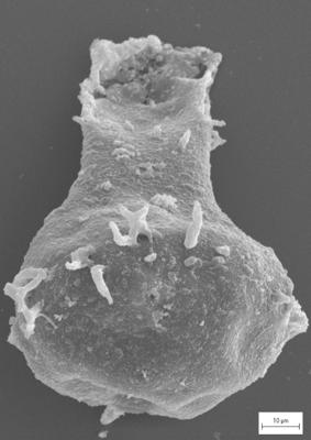
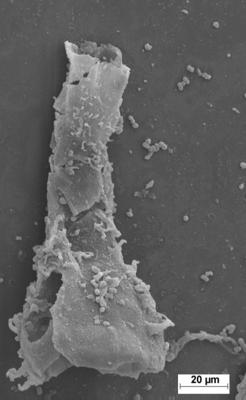
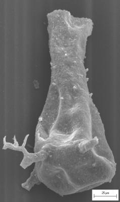
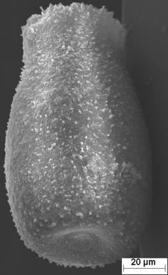
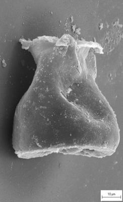
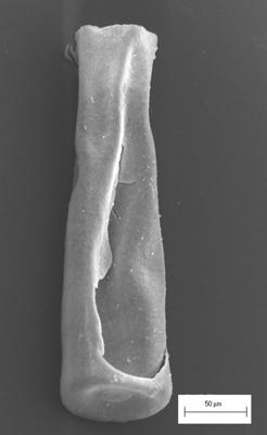
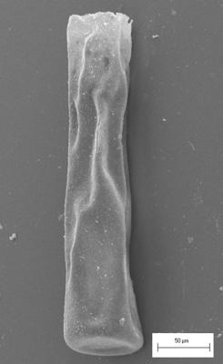
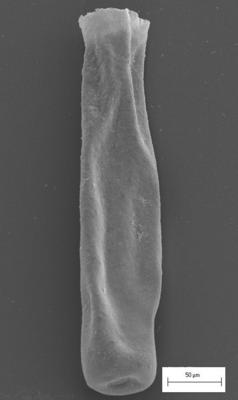
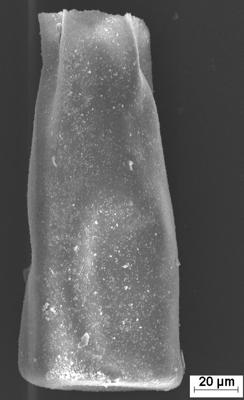
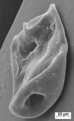
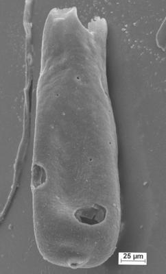
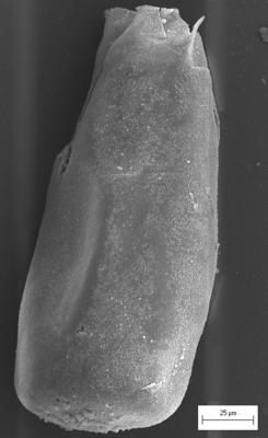
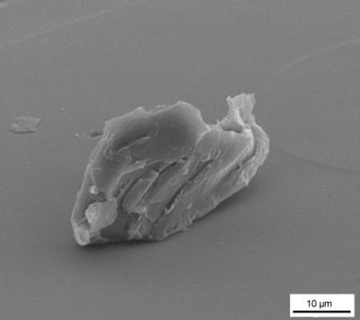
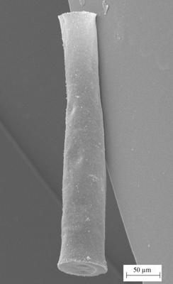
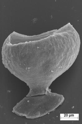
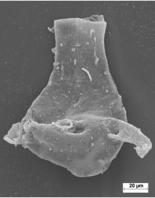
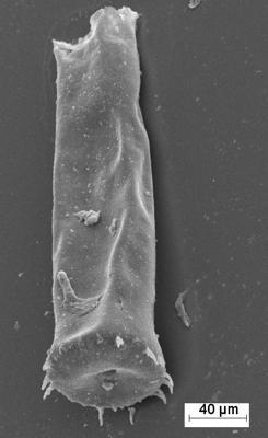
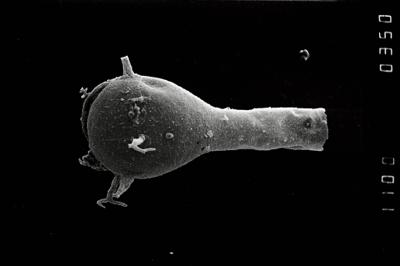
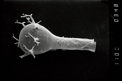
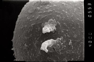
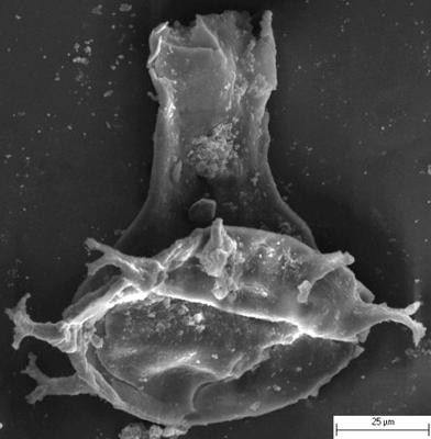
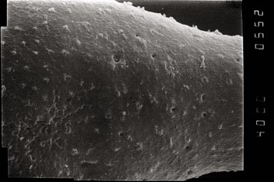
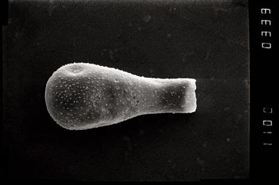
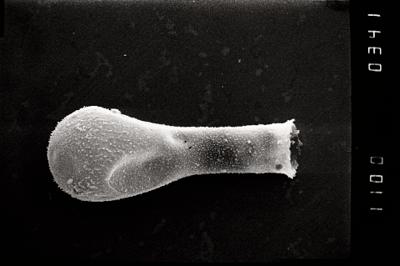
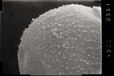
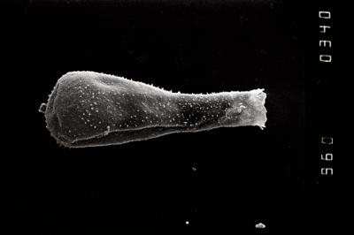
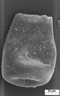
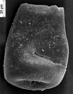
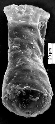
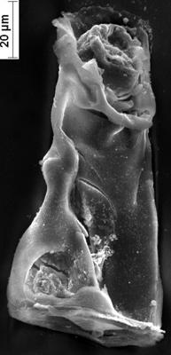
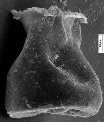
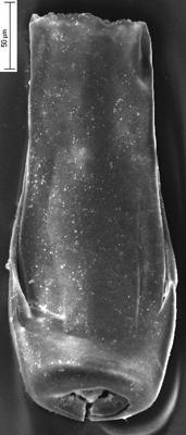
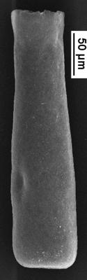
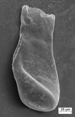
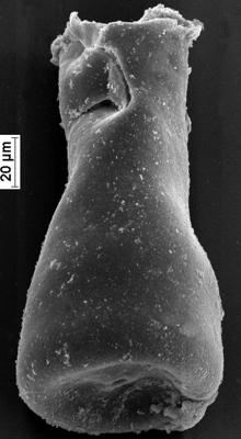
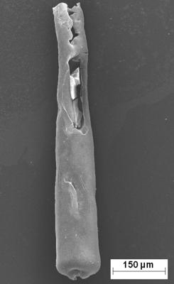
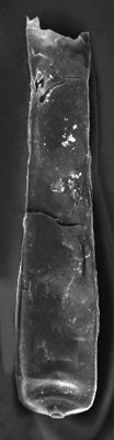
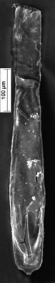
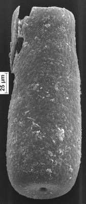
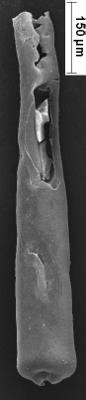
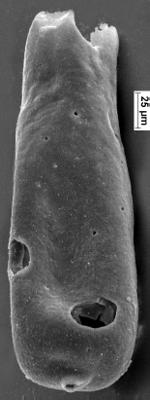
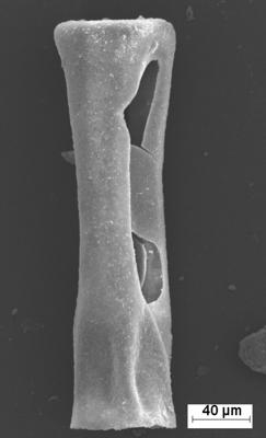
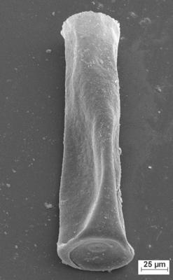
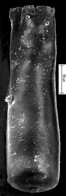
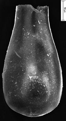
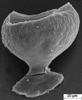
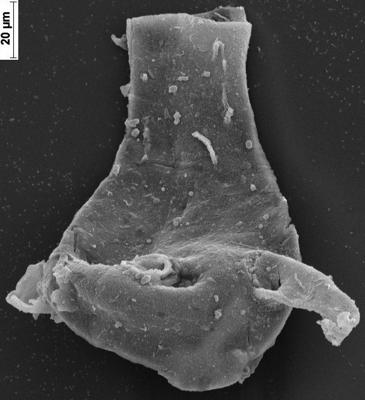
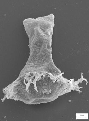
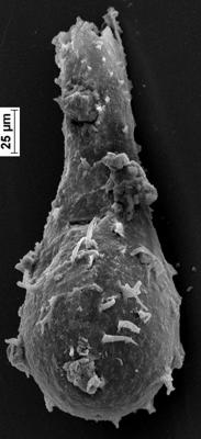
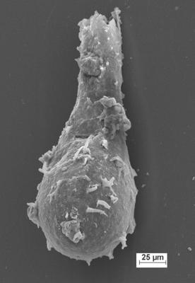
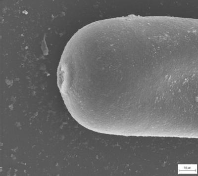
Photos
Tooltip: to show larger image hold Ctrl-key when clicking on image.