Localities
... or show all sections
Häädemeeste 172 borehole
Show additional data in Estonian Geocollections Portal
|
References (1)
Raw data (56 species, 161 samples)
locality	depth	depth_interval	sample_number	Spinachitina fragilis	Belonechitina postrobusta	Ancyrochitina laevaensis	Belonechitina aspera	Cyathochitina campanulaeformis	Cyathochitina calix	Euconochitina electa	Conochitina iklaensis	Cyathochitina kuckersiana	Ancyrochitina bifurcaspina	Spinachitina maennili	Ancyrochitina ramosaspina	Conochitina elongata	Conochitina alargada	Conochitina edjelensis	Ancyrochitina convexa	Conochitina malleus	Ancyrochitina rumbaensis	Belonechitina oeselensis	Bursachitina nestorae	Conochitina praeproboscifera	Conochitina emmastensis	Eisenackitina dolioliformis	Conochitina leviscapulae	Conochitina visbyensis	Belonechitina cavei	Eisenackitina inanulifera	Eisenackitina causiata 	Belonechitina meifodensis	Angochitina hansonica	Angochitina longicollis	Conochitina proboscifera	Ramochitina ruhnuensis	Margachitina margaritana	Conochitina flamma	Conochitina leptosoma	Ramochitina nestorae	Bursachitina nana	Conochitina aff. tuba	Calpichitina densa	Conochitina claviformis	Plectochitina pachyderma	Conochitina mamilla	Conochitina tuba	Conochitina armillata	Clathrochitina clathrata	Ancyrochitina gutnica	Ancyrochitina paulaspina	Eisenackitina spongiosa	Conochitina argillophila	Conochitina pachycephala	Conochitina subcyatha	Conochitina postproboscifera nom. nud.	Conochitina linearistriata	Conochitina fortis	Ancyrochitina plurispinosa
Häädemeeste 172 borehole	131.30	131.40	M-9088																																										-1		-1			1				-1		-1			-1
Häädemeeste 172 borehole	135.70	135.80	M-9087																																												1							1		1
Häädemeeste 172 borehole	136.00		M-891																																																			1		1
Häädemeeste 172 borehole	137.00		M-890																																															1				1
Häädemeeste 172 borehole	139.00		M-889																																												-1			1								-1	1
Häädemeeste 172 borehole	141.00	141.10	M-9086																																												1							1	1		-1	-1
Häädemeeste 172 borehole	143.00		M-888																																												1						-1	1	1	-1
Häädemeeste 172 borehole	144.10	144.20	M-9085																																									1			-1						-1	1
Häädemeeste 172 borehole	146.50	146.60	M-9084																																									1								-1	1
Häädemeeste 172 borehole	148.30	148.40	M-9083																																									1									1
Häädemeeste 172 borehole	150.00		M-887																																				-1					1	-1							1	-1
Häädemeeste 172 borehole	152.30	152.40	M-9082																																				-1					1
Häädemeeste 172 borehole	153.40	153.50	M-9081																																									1			-1
Häädemeeste 172 borehole	155.90	156.00	M-9080																																									-1
Häädemeeste 172 borehole	158.00		M-886																																									1
Häädemeeste 172 borehole	159.50	159.60	M-9079																																									1						-1
Häädemeeste 172 borehole	166.20	166.30	M-9077																																									1			-1
Häädemeeste 172 borehole	167.00		M-885																																				-1					1			1
Häädemeeste 172 borehole	168.50	168.60	M-9076																																									1			-1				-1
Häädemeeste 172 borehole	171.20	171.30	M-9075																																		-1		-1					1
Häädemeeste 172 borehole	173.50	173.60	M-9074																																									1
Häädemeeste 172 borehole	176.00		M-884																																									1			1				-1
Häädemeeste 172 borehole	178.00	178.00	M-9073																																		1							1			1
Häädemeeste 172 borehole	179.90	180.00	M-9072																																		1							1			1	-1	1	1
Häädemeeste 172 borehole	182.00		M-883																																									1			1	1
Häädemeeste 172 borehole	184.00		M-882																																									1			1	-1
Häädemeeste 172 borehole	185.00		M-881																																									1	-1		-1
Häädemeeste 172 borehole	186.00		M-880																																		1											1
Häädemeeste 172 borehole	188.00		M-879																																		1							1			1
Häädemeeste 172 borehole	190.00		M-878																																									1			1
Häädemeeste 172 borehole	191.80	191.90	M-9071																																									1		-1	1
Häädemeeste 172 borehole	194.00		M-877																																		1							1		-1	1
Häädemeeste 172 borehole	196.50	196.60	M-9070																																									1
Häädemeeste 172 borehole	198.45	198.55	M-9069																																									1	1	-1
Häädemeeste 172 borehole	200.30	200.40	M-9068																																		1		1					1	-1
Häädemeeste 172 borehole	205.00	205.10	M-9066																											1	1				1		1						1
Häädemeeste 172 borehole	206.35	206.45	M-9065																											1	1				1		1
Häädemeeste 172 borehole	208.00		M-876																									-1		-1							1
Häädemeeste 172 borehole	210.00		M-875																							-1				-1				1	1		1			1	1	1
Häädemeeste 172 borehole	210.60	210.70	M-9064																									1		1	1				1
Häädemeeste 172 borehole	212.40		M-874																												1			1		1		-1	-1
Häädemeeste 172 borehole	212.50		M-873																									1		1	1			1		1	1
Häädemeeste 172 borehole	213.00		M-872																											-1						1	1
Häädemeeste 172 borehole	213.70		M-871																									1						1	1
Häädemeeste 172 borehole	215.30	215.40	M-9063
Häädemeeste 172 borehole	216.00		M-870
Häädemeeste 172 borehole	217.00		M-869																														-1
Häädemeeste 172 borehole	220.00		M-866																		-1				-1	1
Häädemeeste 172 borehole	220.70	220.80	M-9062																							1		1		1	1	1
Häädemeeste 172 borehole	221.30	221.40	M-9061																						-1		-1	-1	1	1	1
Häädemeeste 172 borehole	222.70	222.80	M-9060																		-1			1
Häädemeeste 172 borehole	224.15	224.20	M-9059																				-1
Häädemeeste 172 borehole	225.00		M-865
Häädemeeste 172 borehole	226.10	226.20	M-9058																				1					-1
Häädemeeste 172 borehole	227.20	227.30	M-9057																			1	1
Häädemeeste 172 borehole	228.45	228.55	M-9056														1			1							1
Häädemeeste 172 borehole	229.60	229.70	M-9055													-1						1	1			-1
Häädemeeste 172 borehole	230.80	230.90	M-9054								-1					-1						1	1	-1	-1	-1
Häädemeeste 172 borehole	231.30	231.30	M-864													-1	-1				-1
Häädemeeste 172 borehole	232.40	232.50	M-9053								1					1	1	1		-1
Häädemeeste 172 borehole	234.50	234.60	M-9052								1					1	1	-1
Häädemeeste 172 borehole	236.70	236.80	M-9051								1					-1	1
Häädemeeste 172 borehole	238.65	238.70	M-9050															1
Häädemeeste 172 borehole	240.80	240.90	M-9049													1
Häädemeeste 172 borehole	243.20	243.30	M-9048													1	1	1
Häädemeeste 172 borehole	245.20	245.30	M-9047													1
Häädemeeste 172 borehole	247.20	247.30	M-9046													1	1
Häädemeeste 172 borehole	249.30	249.40	M-9045
Häädemeeste 172 borehole	253.70	253.80	M-9043													-1				-1
Häädemeeste 172 borehole	255.00		M-862								-1					-1				-1
Häädemeeste 172 borehole	256.30	256.40	M-9042								-1					-1	-1			-1
Häädemeeste 172 borehole	258.80	258.90	M-9041													1		1
Häädemeeste 172 borehole	261.00	261.10	M-9040													-1	-1
Häädemeeste 172 borehole	263.00	263.10	M-9039													1	1			-1
Häädemeeste 172 borehole	264.90	265.00	M-9038													-1
Häädemeeste 172 borehole	266.90	267.00	M-9037													-1	-1
Häädemeeste 172 borehole	268.80	268.90	M-9036													-1
Häädemeeste 172 borehole	274.40	274.50	M-9035									-1		1					1	-1
Häädemeeste 172 borehole	275.40	275.50	M-9034								-1	-1		1		1			1
Häädemeeste 172 borehole	277.70	277.80	M-9033								1			1		1		1	1
Häädemeeste 172 borehole	279.55	279.65	M-9032													1
Häädemeeste 172 borehole	282.10	282.20	M-9031									-1							1
Häädemeeste 172 borehole	283.90	284.00	M-9030								-1					1				-1
Häädemeeste 172 borehole	286.60	286.70	M-9029								1			-1		1		-1		1
Häädemeeste 172 borehole	289.00	289.10	M-9028											1		-1			-1
Häädemeeste 172 borehole	290.90	291.00	M-9027											1		1			-1
Häädemeeste 172 borehole	293.00	293.10	M-9026								1			1		-1	1		1
Häädemeeste 172 borehole	294.90	295.00	M-9025								1			1		1		1
Häädemeeste 172 borehole	297.00	297.10	M-9024								-1					1		1
Häädemeeste 172 borehole	299.00	299.10	M-9023								1					1		1		1
Häädemeeste 172 borehole	300.00		M-861											1		1	-1			-1
Häädemeeste 172 borehole	301.10	301.20	M-9022								-1					1	1	-1	-1
Häädemeeste 172 borehole	303.20	303.30	M-9021								1					1	1	1
Häädemeeste 172 borehole	306.10	306.20	M-9020								-1					1	-1	1		-1
Häädemeeste 172 borehole	308.70	308.80	M-9019													1	-1	1		-1
Häädemeeste 172 borehole	311.20	311.30	M-9018								-1					1		1	-1	1
Häädemeeste 172 borehole	313.40	313.50	M-9017								1					1	1	-1	1
Häädemeeste 172 borehole	315.00	315.10	M-9016								1					1	1
Häädemeeste 172 borehole	317.10	317.20	M-9015								1			1		1	-1	1
Häädemeeste 172 borehole	319.10	319.20	M-9014								1			1		1	-1	1
Häädemeeste 172 borehole	321.20	321.30	M-9013								1			1		1	-1	1
Häädemeeste 172 borehole	323.10	323.20	M-9012								1			1
Häädemeeste 172 borehole	325.00	325.10	M-9011								1			1
Häädemeeste 172 borehole	327.20	327.30	M-9010											1			1
Häädemeeste 172 borehole	329.40	329.50	M-9009								1			1	-1
Häädemeeste 172 borehole	332.00	332.10	M-9008								1			1		-1
Häädemeeste 172 borehole	334.00	334.10	M-9007								1			1	-1	-1
Häädemeeste 172 borehole	335.70	335.80	M-9006								1			1
Häädemeeste 172 borehole	337.80	337.90	M-9005								1	1		1
Häädemeeste 172 borehole	340.00	340.00	M-360								1	1		1
Häädemeeste 172 borehole	340.50	340.60	M-9004								1			1
Häädemeeste 172 borehole	342.70	342.80	M-9003								1	1		1
Häädemeeste 172 borehole	348.40	348.50	M-9002							-1
Häädemeeste 172 borehole	350.70	350.80	M-9001					-1	1
Häädemeeste 172 borehole	353.20	353.30	M-9000					1
Häädemeeste 172 borehole	356.10	356.20	M-8099						1	-1	1			1
Häädemeeste 172 borehole	358.70	358.80	M-8098							1				1
Häädemeeste 172 borehole	361.00	361.10	M-8097							1				1
Häädemeeste 172 borehole	363.20	363.30	M-8096							1				1
Häädemeeste 172 borehole	365.40	365.50	M-8095					1	1					1
Häädemeeste 172 borehole	367.30	367.40	M-8094							1				1
Häädemeeste 172 borehole	369.20	369.30	M-8093					1	1	1	-1
Häädemeeste 172 borehole	371.30	371.40	M-8092					1	1	1	1
Häädemeeste 172 borehole	373.20	372.30	M-8091					1	1		1
Häädemeeste 172 borehole	375.00		M-859						1	1	1
Häädemeeste 172 borehole	375.20	375.30	M-8090					-1	1	1	-1
Häädemeeste 172 borehole	377.15	377.25	M-8089					1	1	1	1
Häädemeeste 172 borehole	377.70	377.80	M-8088						1	1	1
Häädemeeste 172 borehole	378.80	378.90	M-8087					1	1	1	1
Häädemeeste 172 borehole	379.80	379.90	M-8086					1	1	1	1		1
Häädemeeste 172 borehole	380.90	381.00	M-8085					-1	-1	1	1
Häädemeeste 172 borehole	381.90	382.00	M-8084							1	1
Häädemeeste 172 borehole	382.90	383.00	M-8083							1	1
Häädemeeste 172 borehole	384.00		M-858								-1		1
Häädemeeste 172 borehole	384.80	384.90	M-8082								-1
Häädemeeste 172 borehole	385.80	385.90	M-8081							-1		1
Häädemeeste 172 borehole	386.00		M-857							1			1
Häädemeeste 172 borehole	387.00		M-856							1	-1
Häädemeeste 172 borehole	387.80	387.90	M-8080		1		-1			1	1	1
Häädemeeste 172 borehole	388.80	389.00	M-8079		1						-1	1	1
Häädemeeste 172 borehole	390.00		M-855		1		1					1
Häädemeeste 172 borehole	391.10	391.20	M-8078		1		-1					1
Häädemeeste 172 borehole	392.00		M-854		1		1					1
Häädemeeste 172 borehole	393.90	394.00	M-8077		1		1	1	1	1		1
Häädemeeste 172 borehole	395.00	395.10	M-8076					-1		-1	-1	1
Häädemeeste 172 borehole	397.20	397.30	M-8075		1		1	1	1	1	1	1
Häädemeeste 172 borehole	398.20	398.30	M-8074		1		1	1	1	1		1
Häädemeeste 172 borehole	400.00		M-853		1		1			1	1
Häädemeeste 172 borehole	401.10	401.20	M-8073		1		1	1	1
Häädemeeste 172 borehole	403.20	403.30	M-8072		1			-1	1
Häädemeeste 172 borehole	405.10	405.20	M-8071		-1			-1	1
Häädemeeste 172 borehole	407.00	407.10	M-8070					-1	1
Häädemeeste 172 borehole	408.50	408.60	M-8069						1
Häädemeeste 172 borehole	410.70	410.80	M-8068					-1
Häädemeeste 172 borehole	412.20	412.80	M-8067
Häädemeeste 172 borehole	420.90	421.00	M-8065					1
Häädemeeste 172 borehole	423.00		M-852	-1	1
Häädemeeste 172 borehole	423.40	423.50	M-8064
Häädemeeste 172 borehole	424.00		M-851
Häädemeeste 172 borehole	425.00		M-850	-1	1	1	1	-1
Häädemeeste 172 borehole	425.50	425.60	M-8062	1	1
| locality | depth | depth_interval | sample_number | Spinachitina fragilis | Belonechitina postrobusta | Ancyrochitina laevaensis | Belonechitina aspera | Cyathochitina campanulaeformis | Cyathochitina calix | Euconochitina electa | Conochitina iklaensis | Cyathochitina kuckersiana | Ancyrochitina bifurcaspina | Spinachitina maennili | Ancyrochitina ramosaspina | Conochitina elongata | Conochitina alargada | Conochitina edjelensis | Ancyrochitina convexa | Conochitina malleus | Ancyrochitina rumbaensis | Belonechitina oeselensis | Bursachitina nestorae | Conochitina praeproboscifera | Conochitina emmastensis | Eisenackitina dolioliformis | Conochitina leviscapulae | Conochitina visbyensis | Belonechitina cavei | Eisenackitina inanulifera | Eisenackitina causiata | Belonechitina meifodensis | Angochitina hansonica | Angochitina longicollis | Conochitina proboscifera | Ramochitina ruhnuensis | Margachitina margaritana | Conochitina flamma | Conochitina leptosoma | Ramochitina nestorae | Bursachitina nana | Conochitina aff. tuba | Calpichitina densa | Conochitina claviformis | Plectochitina pachyderma | Conochitina mamilla | Conochitina tuba | Conochitina armillata | Clathrochitina clathrata | Ancyrochitina gutnica | Ancyrochitina paulaspina | Eisenackitina spongiosa | Conochitina argillophila | Conochitina pachycephala | Conochitina subcyatha | Conochitina postproboscifera nom. nud. | Conochitina linearistriata | Conochitina fortis | Ancyrochitina plurispinosa |
|---|---|---|---|---|---|---|---|---|---|---|---|---|---|---|---|---|---|---|---|---|---|---|---|---|---|---|---|---|---|---|---|---|---|---|---|---|---|---|---|---|---|---|---|---|---|---|---|---|---|---|---|---|---|---|---|---|---|---|---|
| Häädemeeste 172 borehole | 131.30 | 131.40 | M-9088 | -1 | -1 | 1 | -1 | -1 | -1 | ||||||||||||||||||||||||||||||||||||||||||||||||||
| Häädemeeste 172 borehole | 135.70 | 135.80 | M-9087 | 1 | 1 | 1 | |||||||||||||||||||||||||||||||||||||||||||||||||||||
| Häädemeeste 172 borehole | 136.00 | M-891 | 1 | 1 | |||||||||||||||||||||||||||||||||||||||||||||||||||||||
| Häädemeeste 172 borehole | 137.00 | M-890 | 1 | 1 | |||||||||||||||||||||||||||||||||||||||||||||||||||||||
| Häädemeeste 172 borehole | 139.00 | M-889 | -1 | 1 | -1 | 1 | |||||||||||||||||||||||||||||||||||||||||||||||||||||
| Häädemeeste 172 borehole | 141.00 | 141.10 | M-9086 | 1 | 1 | 1 | -1 | -1 | |||||||||||||||||||||||||||||||||||||||||||||||||||
| Häädemeeste 172 borehole | 143.00 | M-888 | 1 | -1 | 1 | 1 | -1 | ||||||||||||||||||||||||||||||||||||||||||||||||||||
| Häädemeeste 172 borehole | 144.10 | 144.20 | M-9085 | 1 | -1 | -1 | 1 | ||||||||||||||||||||||||||||||||||||||||||||||||||||
| Häädemeeste 172 borehole | 146.50 | 146.60 | M-9084 | 1 | -1 | 1 | |||||||||||||||||||||||||||||||||||||||||||||||||||||
| Häädemeeste 172 borehole | 148.30 | 148.40 | M-9083 | 1 | 1 | ||||||||||||||||||||||||||||||||||||||||||||||||||||||
| Häädemeeste 172 borehole | 150.00 | M-887 | -1 | 1 | -1 | 1 | -1 | ||||||||||||||||||||||||||||||||||||||||||||||||||||
| Häädemeeste 172 borehole | 152.30 | 152.40 | M-9082 | -1 | 1 | ||||||||||||||||||||||||||||||||||||||||||||||||||||||
| Häädemeeste 172 borehole | 153.40 | 153.50 | M-9081 | 1 | -1 | ||||||||||||||||||||||||||||||||||||||||||||||||||||||
| Häädemeeste 172 borehole | 155.90 | 156.00 | M-9080 | -1 | |||||||||||||||||||||||||||||||||||||||||||||||||||||||
| Häädemeeste 172 borehole | 158.00 | M-886 | 1 | ||||||||||||||||||||||||||||||||||||||||||||||||||||||||
| Häädemeeste 172 borehole | 159.50 | 159.60 | M-9079 | 1 | -1 | ||||||||||||||||||||||||||||||||||||||||||||||||||||||
| Häädemeeste 172 borehole | 166.20 | 166.30 | M-9077 | 1 | -1 | ||||||||||||||||||||||||||||||||||||||||||||||||||||||
| Häädemeeste 172 borehole | 167.00 | M-885 | -1 | 1 | 1 | ||||||||||||||||||||||||||||||||||||||||||||||||||||||
| Häädemeeste 172 borehole | 168.50 | 168.60 | M-9076 | 1 | -1 | -1 | |||||||||||||||||||||||||||||||||||||||||||||||||||||
| Häädemeeste 172 borehole | 171.20 | 171.30 | M-9075 | -1 | -1 | 1 | |||||||||||||||||||||||||||||||||||||||||||||||||||||
| Häädemeeste 172 borehole | 173.50 | 173.60 | M-9074 | 1 | |||||||||||||||||||||||||||||||||||||||||||||||||||||||
| Häädemeeste 172 borehole | 176.00 | M-884 | 1 | 1 | -1 | ||||||||||||||||||||||||||||||||||||||||||||||||||||||
| Häädemeeste 172 borehole | 178.00 | 178.00 | M-9073 | 1 | 1 | 1 | |||||||||||||||||||||||||||||||||||||||||||||||||||||
| Häädemeeste 172 borehole | 179.90 | 180.00 | M-9072 | 1 | 1 | 1 | -1 | 1 | 1 | ||||||||||||||||||||||||||||||||||||||||||||||||||
| Häädemeeste 172 borehole | 182.00 | M-883 | 1 | 1 | 1 | ||||||||||||||||||||||||||||||||||||||||||||||||||||||
| Häädemeeste 172 borehole | 184.00 | M-882 | 1 | 1 | -1 | ||||||||||||||||||||||||||||||||||||||||||||||||||||||
| Häädemeeste 172 borehole | 185.00 | M-881 | 1 | -1 | -1 | ||||||||||||||||||||||||||||||||||||||||||||||||||||||
| Häädemeeste 172 borehole | 186.00 | M-880 | 1 | 1 | |||||||||||||||||||||||||||||||||||||||||||||||||||||||
| Häädemeeste 172 borehole | 188.00 | M-879 | 1 | 1 | 1 | ||||||||||||||||||||||||||||||||||||||||||||||||||||||
| Häädemeeste 172 borehole | 190.00 | M-878 | 1 | 1 | |||||||||||||||||||||||||||||||||||||||||||||||||||||||
| Häädemeeste 172 borehole | 191.80 | 191.90 | M-9071 | 1 | -1 | 1 | |||||||||||||||||||||||||||||||||||||||||||||||||||||
| Häädemeeste 172 borehole | 194.00 | M-877 | 1 | 1 | -1 | 1 | |||||||||||||||||||||||||||||||||||||||||||||||||||||
| Häädemeeste 172 borehole | 196.50 | 196.60 | M-9070 | 1 | |||||||||||||||||||||||||||||||||||||||||||||||||||||||
| Häädemeeste 172 borehole | 198.45 | 198.55 | M-9069 | 1 | 1 | -1 | |||||||||||||||||||||||||||||||||||||||||||||||||||||
| Häädemeeste 172 borehole | 200.30 | 200.40 | M-9068 | 1 | 1 | 1 | -1 | ||||||||||||||||||||||||||||||||||||||||||||||||||||
| Häädemeeste 172 borehole | 205.00 | 205.10 | M-9066 | 1 | 1 | 1 | 1 | 1 | |||||||||||||||||||||||||||||||||||||||||||||||||||
| Häädemeeste 172 borehole | 206.35 | 206.45 | M-9065 | 1 | 1 | 1 | 1 | ||||||||||||||||||||||||||||||||||||||||||||||||||||
| Häädemeeste 172 borehole | 208.00 | M-876 | -1 | -1 | 1 | ||||||||||||||||||||||||||||||||||||||||||||||||||||||
| Häädemeeste 172 borehole | 210.00 | M-875 | -1 | -1 | 1 | 1 | 1 | 1 | 1 | 1 | |||||||||||||||||||||||||||||||||||||||||||||||||
| Häädemeeste 172 borehole | 210.60 | 210.70 | M-9064 | 1 | 1 | 1 | 1 | ||||||||||||||||||||||||||||||||||||||||||||||||||||
| Häädemeeste 172 borehole | 212.40 | M-874 | 1 | 1 | 1 | -1 | -1 | ||||||||||||||||||||||||||||||||||||||||||||||||||||
| Häädemeeste 172 borehole | 212.50 | M-873 | 1 | 1 | 1 | 1 | 1 | 1 | |||||||||||||||||||||||||||||||||||||||||||||||||||
| Häädemeeste 172 borehole | 213.00 | M-872 | -1 | 1 | 1 | ||||||||||||||||||||||||||||||||||||||||||||||||||||||
| Häädemeeste 172 borehole | 213.70 | M-871 | 1 | 1 | 1 | ||||||||||||||||||||||||||||||||||||||||||||||||||||||
| Häädemeeste 172 borehole | 215.30 | 215.40 | M-9063 | ||||||||||||||||||||||||||||||||||||||||||||||||||||||||
| Häädemeeste 172 borehole | 216.00 | M-870 | |||||||||||||||||||||||||||||||||||||||||||||||||||||||||
| Häädemeeste 172 borehole | 217.00 | M-869 | -1 | ||||||||||||||||||||||||||||||||||||||||||||||||||||||||
| Häädemeeste 172 borehole | 220.00 | M-866 | -1 | -1 | 1 | ||||||||||||||||||||||||||||||||||||||||||||||||||||||
| Häädemeeste 172 borehole | 220.70 | 220.80 | M-9062 | 1 | 1 | 1 | 1 | 1 | |||||||||||||||||||||||||||||||||||||||||||||||||||
| Häädemeeste 172 borehole | 221.30 | 221.40 | M-9061 | -1 | -1 | -1 | 1 | 1 | 1 | ||||||||||||||||||||||||||||||||||||||||||||||||||
| Häädemeeste 172 borehole | 222.70 | 222.80 | M-9060 | -1 | 1 | ||||||||||||||||||||||||||||||||||||||||||||||||||||||
| Häädemeeste 172 borehole | 224.15 | 224.20 | M-9059 | -1 | |||||||||||||||||||||||||||||||||||||||||||||||||||||||
| Häädemeeste 172 borehole | 225.00 | M-865 | |||||||||||||||||||||||||||||||||||||||||||||||||||||||||
| Häädemeeste 172 borehole | 226.10 | 226.20 | M-9058 | 1 | -1 | ||||||||||||||||||||||||||||||||||||||||||||||||||||||
| Häädemeeste 172 borehole | 227.20 | 227.30 | M-9057 | 1 | 1 | ||||||||||||||||||||||||||||||||||||||||||||||||||||||
| Häädemeeste 172 borehole | 228.45 | 228.55 | M-9056 | 1 | 1 | 1 | |||||||||||||||||||||||||||||||||||||||||||||||||||||
| Häädemeeste 172 borehole | 229.60 | 229.70 | M-9055 | -1 | 1 | 1 | -1 | ||||||||||||||||||||||||||||||||||||||||||||||||||||
| Häädemeeste 172 borehole | 230.80 | 230.90 | M-9054 | -1 | -1 | 1 | 1 | -1 | -1 | -1 | |||||||||||||||||||||||||||||||||||||||||||||||||
| Häädemeeste 172 borehole | 231.30 | 231.30 | M-864 | -1 | -1 | -1 | |||||||||||||||||||||||||||||||||||||||||||||||||||||
| Häädemeeste 172 borehole | 232.40 | 232.50 | M-9053 | 1 | 1 | 1 | 1 | -1 | |||||||||||||||||||||||||||||||||||||||||||||||||||
| Häädemeeste 172 borehole | 234.50 | 234.60 | M-9052 | 1 | 1 | 1 | -1 | ||||||||||||||||||||||||||||||||||||||||||||||||||||
| Häädemeeste 172 borehole | 236.70 | 236.80 | M-9051 | 1 | -1 | 1 | |||||||||||||||||||||||||||||||||||||||||||||||||||||
| Häädemeeste 172 borehole | 238.65 | 238.70 | M-9050 | 1 | |||||||||||||||||||||||||||||||||||||||||||||||||||||||
| Häädemeeste 172 borehole | 240.80 | 240.90 | M-9049 | 1 | |||||||||||||||||||||||||||||||||||||||||||||||||||||||
| Häädemeeste 172 borehole | 243.20 | 243.30 | M-9048 | 1 | 1 | 1 | |||||||||||||||||||||||||||||||||||||||||||||||||||||
| Häädemeeste 172 borehole | 245.20 | 245.30 | M-9047 | 1 | |||||||||||||||||||||||||||||||||||||||||||||||||||||||
| Häädemeeste 172 borehole | 247.20 | 247.30 | M-9046 | 1 | 1 | ||||||||||||||||||||||||||||||||||||||||||||||||||||||
| Häädemeeste 172 borehole | 249.30 | 249.40 | M-9045 | ||||||||||||||||||||||||||||||||||||||||||||||||||||||||
| Häädemeeste 172 borehole | 253.70 | 253.80 | M-9043 | -1 | -1 | ||||||||||||||||||||||||||||||||||||||||||||||||||||||
| Häädemeeste 172 borehole | 255.00 | M-862 | -1 | -1 | -1 | ||||||||||||||||||||||||||||||||||||||||||||||||||||||
| Häädemeeste 172 borehole | 256.30 | 256.40 | M-9042 | -1 | -1 | -1 | -1 | ||||||||||||||||||||||||||||||||||||||||||||||||||||
| Häädemeeste 172 borehole | 258.80 | 258.90 | M-9041 | 1 | 1 | ||||||||||||||||||||||||||||||||||||||||||||||||||||||
| Häädemeeste 172 borehole | 261.00 | 261.10 | M-9040 | -1 | -1 | ||||||||||||||||||||||||||||||||||||||||||||||||||||||
| Häädemeeste 172 borehole | 263.00 | 263.10 | M-9039 | 1 | 1 | -1 | |||||||||||||||||||||||||||||||||||||||||||||||||||||
| Häädemeeste 172 borehole | 264.90 | 265.00 | M-9038 | -1 | |||||||||||||||||||||||||||||||||||||||||||||||||||||||
| Häädemeeste 172 borehole | 266.90 | 267.00 | M-9037 | -1 | -1 | ||||||||||||||||||||||||||||||||||||||||||||||||||||||
| Häädemeeste 172 borehole | 268.80 | 268.90 | M-9036 | -1 | |||||||||||||||||||||||||||||||||||||||||||||||||||||||
| Häädemeeste 172 borehole | 274.40 | 274.50 | M-9035 | -1 | 1 | 1 | -1 | ||||||||||||||||||||||||||||||||||||||||||||||||||||
| Häädemeeste 172 borehole | 275.40 | 275.50 | M-9034 | -1 | -1 | 1 | 1 | 1 | |||||||||||||||||||||||||||||||||||||||||||||||||||
| Häädemeeste 172 borehole | 277.70 | 277.80 | M-9033 | 1 | 1 | 1 | 1 | 1 | |||||||||||||||||||||||||||||||||||||||||||||||||||
| Häädemeeste 172 borehole | 279.55 | 279.65 | M-9032 | 1 | |||||||||||||||||||||||||||||||||||||||||||||||||||||||
| Häädemeeste 172 borehole | 282.10 | 282.20 | M-9031 | -1 | 1 | ||||||||||||||||||||||||||||||||||||||||||||||||||||||
| Häädemeeste 172 borehole | 283.90 | 284.00 | M-9030 | -1 | 1 | -1 | |||||||||||||||||||||||||||||||||||||||||||||||||||||
| Häädemeeste 172 borehole | 286.60 | 286.70 | M-9029 | 1 | -1 | 1 | -1 | 1 | |||||||||||||||||||||||||||||||||||||||||||||||||||
| Häädemeeste 172 borehole | 289.00 | 289.10 | M-9028 | 1 | -1 | -1 | |||||||||||||||||||||||||||||||||||||||||||||||||||||
| Häädemeeste 172 borehole | 290.90 | 291.00 | M-9027 | 1 | 1 | -1 | |||||||||||||||||||||||||||||||||||||||||||||||||||||
| Häädemeeste 172 borehole | 293.00 | 293.10 | M-9026 | 1 | 1 | -1 | 1 | 1 | |||||||||||||||||||||||||||||||||||||||||||||||||||
| Häädemeeste 172 borehole | 294.90 | 295.00 | M-9025 | 1 | 1 | 1 | 1 | ||||||||||||||||||||||||||||||||||||||||||||||||||||
| Häädemeeste 172 borehole | 297.00 | 297.10 | M-9024 | -1 | 1 | 1 | |||||||||||||||||||||||||||||||||||||||||||||||||||||
| Häädemeeste 172 borehole | 299.00 | 299.10 | M-9023 | 1 | 1 | 1 | 1 | ||||||||||||||||||||||||||||||||||||||||||||||||||||
| Häädemeeste 172 borehole | 300.00 | M-861 | 1 | 1 | -1 | -1 | |||||||||||||||||||||||||||||||||||||||||||||||||||||
| Häädemeeste 172 borehole | 301.10 | 301.20 | M-9022 | -1 | 1 | 1 | -1 | -1 | |||||||||||||||||||||||||||||||||||||||||||||||||||
| Häädemeeste 172 borehole | 303.20 | 303.30 | M-9021 | 1 | 1 | 1 | 1 | ||||||||||||||||||||||||||||||||||||||||||||||||||||
| Häädemeeste 172 borehole | 306.10 | 306.20 | M-9020 | -1 | 1 | -1 | 1 | -1 | |||||||||||||||||||||||||||||||||||||||||||||||||||
| Häädemeeste 172 borehole | 308.70 | 308.80 | M-9019 | 1 | -1 | 1 | -1 | ||||||||||||||||||||||||||||||||||||||||||||||||||||
| Häädemeeste 172 borehole | 311.20 | 311.30 | M-9018 | -1 | 1 | 1 | -1 | 1 | |||||||||||||||||||||||||||||||||||||||||||||||||||
| Häädemeeste 172 borehole | 313.40 | 313.50 | M-9017 | 1 | 1 | 1 | -1 | 1 | |||||||||||||||||||||||||||||||||||||||||||||||||||
| Häädemeeste 172 borehole | 315.00 | 315.10 | M-9016 | 1 | 1 | 1 | |||||||||||||||||||||||||||||||||||||||||||||||||||||
| Häädemeeste 172 borehole | 317.10 | 317.20 | M-9015 | 1 | 1 | 1 | -1 | 1 | |||||||||||||||||||||||||||||||||||||||||||||||||||
| Häädemeeste 172 borehole | 319.10 | 319.20 | M-9014 | 1 | 1 | 1 | -1 | 1 | |||||||||||||||||||||||||||||||||||||||||||||||||||
| Häädemeeste 172 borehole | 321.20 | 321.30 | M-9013 | 1 | 1 | 1 | -1 | 1 | |||||||||||||||||||||||||||||||||||||||||||||||||||
| Häädemeeste 172 borehole | 323.10 | 323.20 | M-9012 | 1 | 1 | ||||||||||||||||||||||||||||||||||||||||||||||||||||||
| Häädemeeste 172 borehole | 325.00 | 325.10 | M-9011 | 1 | 1 | ||||||||||||||||||||||||||||||||||||||||||||||||||||||
| Häädemeeste 172 borehole | 327.20 | 327.30 | M-9010 | 1 | 1 | ||||||||||||||||||||||||||||||||||||||||||||||||||||||
| Häädemeeste 172 borehole | 329.40 | 329.50 | M-9009 | 1 | 1 | -1 | |||||||||||||||||||||||||||||||||||||||||||||||||||||
| Häädemeeste 172 borehole | 332.00 | 332.10 | M-9008 | 1 | 1 | -1 | |||||||||||||||||||||||||||||||||||||||||||||||||||||
| Häädemeeste 172 borehole | 334.00 | 334.10 | M-9007 | 1 | 1 | -1 | -1 | ||||||||||||||||||||||||||||||||||||||||||||||||||||
| Häädemeeste 172 borehole | 335.70 | 335.80 | M-9006 | 1 | 1 | ||||||||||||||||||||||||||||||||||||||||||||||||||||||
| Häädemeeste 172 borehole | 337.80 | 337.90 | M-9005 | 1 | 1 | 1 | |||||||||||||||||||||||||||||||||||||||||||||||||||||
| Häädemeeste 172 borehole | 340.00 | 340.00 | M-360 | 1 | 1 | 1 | |||||||||||||||||||||||||||||||||||||||||||||||||||||
| Häädemeeste 172 borehole | 340.50 | 340.60 | M-9004 | 1 | 1 | ||||||||||||||||||||||||||||||||||||||||||||||||||||||
| Häädemeeste 172 borehole | 342.70 | 342.80 | M-9003 | 1 | 1 | 1 | |||||||||||||||||||||||||||||||||||||||||||||||||||||
| Häädemeeste 172 borehole | 348.40 | 348.50 | M-9002 | -1 | |||||||||||||||||||||||||||||||||||||||||||||||||||||||
| Häädemeeste 172 borehole | 350.70 | 350.80 | M-9001 | -1 | 1 | ||||||||||||||||||||||||||||||||||||||||||||||||||||||
| Häädemeeste 172 borehole | 353.20 | 353.30 | M-9000 | 1 | |||||||||||||||||||||||||||||||||||||||||||||||||||||||
| Häädemeeste 172 borehole | 356.10 | 356.20 | M-8099 | 1 | -1 | 1 | 1 | ||||||||||||||||||||||||||||||||||||||||||||||||||||
| Häädemeeste 172 borehole | 358.70 | 358.80 | M-8098 | 1 | 1 | ||||||||||||||||||||||||||||||||||||||||||||||||||||||
| Häädemeeste 172 borehole | 361.00 | 361.10 | M-8097 | 1 | 1 | ||||||||||||||||||||||||||||||||||||||||||||||||||||||
| Häädemeeste 172 borehole | 363.20 | 363.30 | M-8096 | 1 | 1 | ||||||||||||||||||||||||||||||||||||||||||||||||||||||
| Häädemeeste 172 borehole | 365.40 | 365.50 | M-8095 | 1 | 1 | 1 | |||||||||||||||||||||||||||||||||||||||||||||||||||||
| Häädemeeste 172 borehole | 367.30 | 367.40 | M-8094 | 1 | 1 | ||||||||||||||||||||||||||||||||||||||||||||||||||||||
| Häädemeeste 172 borehole | 369.20 | 369.30 | M-8093 | 1 | 1 | 1 | -1 | ||||||||||||||||||||||||||||||||||||||||||||||||||||
| Häädemeeste 172 borehole | 371.30 | 371.40 | M-8092 | 1 | 1 | 1 | 1 | ||||||||||||||||||||||||||||||||||||||||||||||||||||
| Häädemeeste 172 borehole | 373.20 | 372.30 | M-8091 | 1 | 1 | 1 | |||||||||||||||||||||||||||||||||||||||||||||||||||||
| Häädemeeste 172 borehole | 375.00 | M-859 | 1 | 1 | 1 | ||||||||||||||||||||||||||||||||||||||||||||||||||||||
| Häädemeeste 172 borehole | 375.20 | 375.30 | M-8090 | -1 | 1 | 1 | -1 | ||||||||||||||||||||||||||||||||||||||||||||||||||||
| Häädemeeste 172 borehole | 377.15 | 377.25 | M-8089 | 1 | 1 | 1 | 1 | ||||||||||||||||||||||||||||||||||||||||||||||||||||
| Häädemeeste 172 borehole | 377.70 | 377.80 | M-8088 | 1 | 1 | 1 | |||||||||||||||||||||||||||||||||||||||||||||||||||||
| Häädemeeste 172 borehole | 378.80 | 378.90 | M-8087 | 1 | 1 | 1 | 1 | ||||||||||||||||||||||||||||||||||||||||||||||||||||
| Häädemeeste 172 borehole | 379.80 | 379.90 | M-8086 | 1 | 1 | 1 | 1 | 1 | |||||||||||||||||||||||||||||||||||||||||||||||||||
| Häädemeeste 172 borehole | 380.90 | 381.00 | M-8085 | -1 | -1 | 1 | 1 | ||||||||||||||||||||||||||||||||||||||||||||||||||||
| Häädemeeste 172 borehole | 381.90 | 382.00 | M-8084 | 1 | 1 | ||||||||||||||||||||||||||||||||||||||||||||||||||||||
| Häädemeeste 172 borehole | 382.90 | 383.00 | M-8083 | 1 | 1 | ||||||||||||||||||||||||||||||||||||||||||||||||||||||
| Häädemeeste 172 borehole | 384.00 | M-858 | -1 | 1 | |||||||||||||||||||||||||||||||||||||||||||||||||||||||
| Häädemeeste 172 borehole | 384.80 | 384.90 | M-8082 | -1 | |||||||||||||||||||||||||||||||||||||||||||||||||||||||
| Häädemeeste 172 borehole | 385.80 | 385.90 | M-8081 | -1 | 1 | ||||||||||||||||||||||||||||||||||||||||||||||||||||||
| Häädemeeste 172 borehole | 386.00 | M-857 | 1 | 1 | |||||||||||||||||||||||||||||||||||||||||||||||||||||||
| Häädemeeste 172 borehole | 387.00 | M-856 | 1 | -1 | |||||||||||||||||||||||||||||||||||||||||||||||||||||||
| Häädemeeste 172 borehole | 387.80 | 387.90 | M-8080 | 1 | -1 | 1 | 1 | 1 | |||||||||||||||||||||||||||||||||||||||||||||||||||
| Häädemeeste 172 borehole | 388.80 | 389.00 | M-8079 | 1 | -1 | 1 | 1 | ||||||||||||||||||||||||||||||||||||||||||||||||||||
| Häädemeeste 172 borehole | 390.00 | M-855 | 1 | 1 | 1 | ||||||||||||||||||||||||||||||||||||||||||||||||||||||
| Häädemeeste 172 borehole | 391.10 | 391.20 | M-8078 | 1 | -1 | 1 | |||||||||||||||||||||||||||||||||||||||||||||||||||||
| Häädemeeste 172 borehole | 392.00 | M-854 | 1 | 1 | 1 | ||||||||||||||||||||||||||||||||||||||||||||||||||||||
| Häädemeeste 172 borehole | 393.90 | 394.00 | M-8077 | 1 | 1 | 1 | 1 | 1 | 1 | ||||||||||||||||||||||||||||||||||||||||||||||||||
| Häädemeeste 172 borehole | 395.00 | 395.10 | M-8076 | -1 | -1 | -1 | 1 | ||||||||||||||||||||||||||||||||||||||||||||||||||||
| Häädemeeste 172 borehole | 397.20 | 397.30 | M-8075 | 1 | 1 | 1 | 1 | 1 | 1 | 1 | |||||||||||||||||||||||||||||||||||||||||||||||||
| Häädemeeste 172 borehole | 398.20 | 398.30 | M-8074 | 1 | 1 | 1 | 1 | 1 | 1 | ||||||||||||||||||||||||||||||||||||||||||||||||||
| Häädemeeste 172 borehole | 400.00 | M-853 | 1 | 1 | 1 | 1 | |||||||||||||||||||||||||||||||||||||||||||||||||||||
| Häädemeeste 172 borehole | 401.10 | 401.20 | M-8073 | 1 | 1 | 1 | 1 | ||||||||||||||||||||||||||||||||||||||||||||||||||||
| Häädemeeste 172 borehole | 403.20 | 403.30 | M-8072 | 1 | -1 | 1 | |||||||||||||||||||||||||||||||||||||||||||||||||||||
| Häädemeeste 172 borehole | 405.10 | 405.20 | M-8071 | -1 | -1 | 1 | |||||||||||||||||||||||||||||||||||||||||||||||||||||
| Häädemeeste 172 borehole | 407.00 | 407.10 | M-8070 | -1 | 1 | ||||||||||||||||||||||||||||||||||||||||||||||||||||||
| Häädemeeste 172 borehole | 408.50 | 408.60 | M-8069 | 1 | |||||||||||||||||||||||||||||||||||||||||||||||||||||||
| Häädemeeste 172 borehole | 410.70 | 410.80 | M-8068 | -1 | |||||||||||||||||||||||||||||||||||||||||||||||||||||||
| Häädemeeste 172 borehole | 412.20 | 412.80 | M-8067 | ||||||||||||||||||||||||||||||||||||||||||||||||||||||||
| Häädemeeste 172 borehole | 420.90 | 421.00 | M-8065 | 1 | |||||||||||||||||||||||||||||||||||||||||||||||||||||||
| Häädemeeste 172 borehole | 423.00 | M-852 | -1 | 1 | |||||||||||||||||||||||||||||||||||||||||||||||||||||||
| Häädemeeste 172 borehole | 423.40 | 423.50 | M-8064 | ||||||||||||||||||||||||||||||||||||||||||||||||||||||||
| Häädemeeste 172 borehole | 424.00 | M-851 | |||||||||||||||||||||||||||||||||||||||||||||||||||||||||
| Häädemeeste 172 borehole | 425.00 | M-850 | -1 | 1 | 1 | 1 | -1 | ||||||||||||||||||||||||||||||||||||||||||||||||||||
| Häädemeeste 172 borehole | 425.50 | 425.60 | M-8062 | 1 | 1 |
Show table
Range chart (autogenerated)
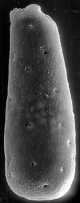
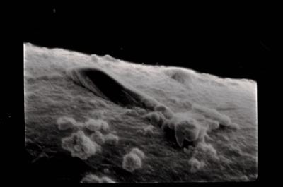
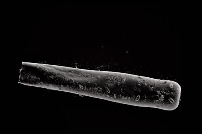
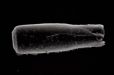
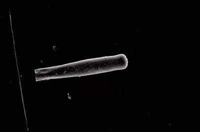
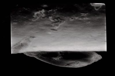
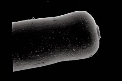
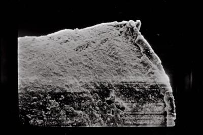
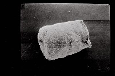
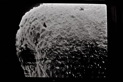
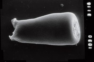
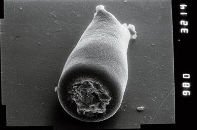
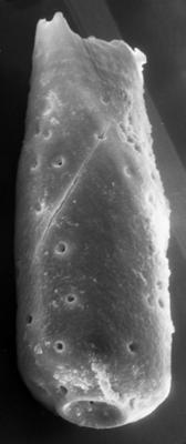
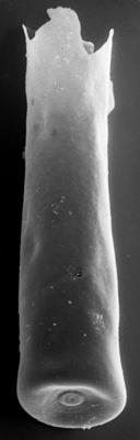
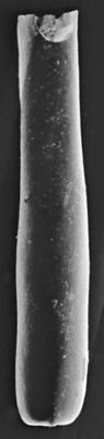
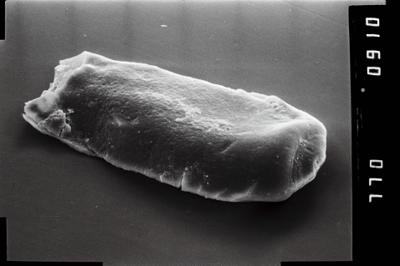
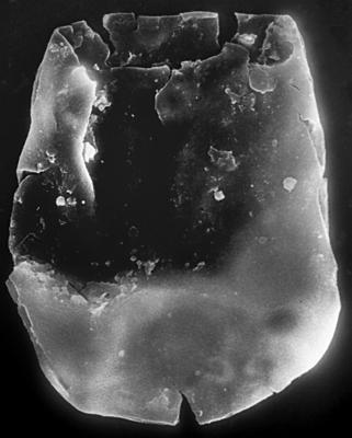
Photos
Tooltip: to show larger image hold Ctrl-key when clicking on image.