Localities
... or show all sections
Riksu 803 borehole
Show additional data in Estonian Geocollections Portal
|
Raw data (34 species, 64 samples)
locality	depth	depth_interval	sample_number	Conochitina proboscifera	Conochitina claviformis	Margachitina margaritana	Plectochitina pachyderma	Ancyrochitina ansarviensis	Eisenackitina inanulifera	Pterochitina macroptera	Conochitina leptosoma	Conochitina mamilla	Ancyrochitina paulaspina	Calpichitina acollaris	Conochitina tuba	Ancyrochitina gutnica	Clathrochitina clathrata	Ramochitina spinosa	Ramochitina uncinata	Conochitina aff. pachycephala	Conochitina argillophila	Conochitina linearistriata	Conochitina postproboscifera nom. nud.	Ancyrochitina plurispinosa	Belonechitina? gutta	Conochitina fortis	Conochitina pachycephala	Conochitina subcyatha	Conochitina sp. 7 (Nestor, 1994)	Plectochitina obuti	Ramochitina tabernaculifera	Conochitina rudda	Angochitina elongata	Belonechitina latifrons	Ancyrochitina gogginensis	Sphaerochitina impia	Ramochitina militaris
Riksu 803 borehole	20.15	20.30	M-11286																														1
Riksu 803 borehole	30.30	30.45	M-11283																															-1
Riksu 803 borehole	31.75	31.90	M-11282				-1																													-1	-1
Riksu 803 borehole	33.50	33.65	M-11281				-1																										1		1	-1
Riksu 803 borehole	35.00	35.15	M-11280																															1
Riksu 803 borehole	36.00	36.10	M-11279																															1
Riksu 803 borehole	37.00	37.15	M-11278																													1	1	1
Riksu 803 borehole	38.05	38.20	M-11277																													1	1	1
Riksu 803 borehole	39.10	39.25	M-11276																														1
Riksu 803 borehole	43.20	43.40	M-11275																													1
Riksu 803 borehole	63.40	63.60	M-11265				1
Riksu 803 borehole	64.60	64.80	M-11264				1
Riksu 803 borehole	81.40	81.60	M-11258
Riksu 803 borehole	83.15	83.30	M-11257												1				1
Riksu 803 borehole	84.70	84.80	M-11256												-1			-1													1
Riksu 803 borehole	85.80	86.00	M-11255				-1								1												-1
Riksu 803 borehole	87.70	87.80	M-11254				1								1				1								1			1
Riksu 803 borehole	89.25	89.40	M-11253												1												-1		-1
Riksu 803 borehole	90.70	90.90	M-11252		1	1	1								-1												-1			-1
Riksu 803 borehole	91.60	91.80	M-11251										1		1	1								1			1
Riksu 803 borehole	93.40	93.50	M-11250										1		1	1			1					1			1
Riksu 803 borehole	94.80	95.00	M-11249												1												1			-1
Riksu 803 borehole	95.50	95.50	M-11248												1												-1	-1	1
Riksu 803 borehole	96.40	96.50	M-11247		-1		1						1		1	-1
Riksu 803 borehole	98.30	98.40	M-11246		1		1								1								-1		1	-1	1
Riksu 803 borehole	99.30	99.60	M-11245		1																		-1	-1
Riksu 803 borehole	100.60	100.70	M-11244		1		1									1							1
Riksu 803 borehole	101.80	102.00	M-11243		1		1						1		1				1		1	1	1
Riksu 803 borehole	103.60	103.75	M-11242		1		-1								-1						-1
Riksu 803 borehole	104.60	104.80	M-11241		-1										1						-1
Riksu 803 borehole	106.00	106.10	M-11240		1	1	1							-1	1						-1
Riksu 803 borehole	107.10	107.30	M-11239		1	1										-1
Riksu 803 borehole	109.10	109.30	M-11238		1		1								1
Riksu 803 borehole	111.30	111.40	M-11237		1								-1		1
Riksu 803 borehole	112.55	112.70	M-11236		1	1									1		1			1
Riksu 803 borehole	113.70	113.90	M-11235		1	1	1						1		-1	-1	1
Riksu 803 borehole	115.35	115.45	M-11234		1										1		1
Riksu 803 borehole	116.45	116.60	M-11233		1										-1		1	-1	1
Riksu 803 borehole	117.55	117.70	M-11232		1										-1		1
Riksu 803 borehole	118.80	118.90	M-11231		1								1		1	-1
Riksu 803 borehole	120.00	120.20	M-11230		1										-1
Riksu 803 borehole	121.60	121.70	M-11229		1	1	1								-1
Riksu 803 borehole	123.10	123.30	M-11228		1	1	-1							-1	1	-1
Riksu 803 borehole	124.90	125.00	M-11227		1
Riksu 803 borehole	126.80	126.90	M-11226		1	1						1		1
Riksu 803 borehole	128.60	128.80	M-11225		1	1									-1
Riksu 803 borehole	129.90	130.00	M-11224		1		1						-1		-1	1
Riksu 803 borehole	131.10	131.20	M-11223		1		1								1
Riksu 803 borehole	132.35	132.50	M-11222		1						1				-1
Riksu 803 borehole	133.50	133.60	M-11221		1		1				1		1		1	-1
Riksu 803 borehole	135.00	135.20	M-11220		1										1
Riksu 803 borehole	136.60	136.80	M-11219		1	1	1								1
Riksu 803 borehole	138.60	138.80	M-11218		1	1	1								1
Riksu 803 borehole	140.00	140.20	M-11217		1	1	1								1
Riksu 803 borehole	141.50	141.70	M-11216		1		1						1	1
Riksu 803 borehole	142.50	142.70	M-11215		1	1	1
Riksu 803 borehole	144.40	144.50	M-11214		1	1	-1					-1	-1
Riksu 803 borehole	145.40	145.50	M-11213		1		-1					1	1
Riksu 803 borehole	146.40	146.50	M-11212		1						1
Riksu 803 borehole	147.40	147.50	M-11211		1						1	-1
Riksu 803 borehole	148.50	148.70	M-11210			1				1	1	-1
Riksu 803 borehole	151.40	151.50	M-11209	1	1	1	1	-1	1
Riksu 803 borehole	152.50	152.60	M-11208	1	1	1	1
Riksu 803 borehole	153.40	153.50	M-11206	1	1	1	1
| locality | depth | depth_interval | sample_number | Conochitina proboscifera | Conochitina claviformis | Margachitina margaritana | Plectochitina pachyderma | Ancyrochitina ansarviensis | Eisenackitina inanulifera | Pterochitina macroptera | Conochitina leptosoma | Conochitina mamilla | Ancyrochitina paulaspina | Calpichitina acollaris | Conochitina tuba | Ancyrochitina gutnica | Clathrochitina clathrata | Ramochitina spinosa | Ramochitina uncinata | Conochitina aff. pachycephala | Conochitina argillophila | Conochitina linearistriata | Conochitina postproboscifera nom. nud. | Ancyrochitina plurispinosa | Belonechitina? gutta | Conochitina fortis | Conochitina pachycephala | Conochitina subcyatha | Conochitina sp. 7 (Nestor, 1994) | Plectochitina obuti | Ramochitina tabernaculifera | Conochitina rudda | Angochitina elongata | Belonechitina latifrons | Ancyrochitina gogginensis | Sphaerochitina impia | Ramochitina militaris |
|---|---|---|---|---|---|---|---|---|---|---|---|---|---|---|---|---|---|---|---|---|---|---|---|---|---|---|---|---|---|---|---|---|---|---|---|---|---|
| Riksu 803 borehole | 20.15 | 20.30 | M-11286 | 1 | |||||||||||||||||||||||||||||||||
| Riksu 803 borehole | 30.30 | 30.45 | M-11283 | -1 | |||||||||||||||||||||||||||||||||
| Riksu 803 borehole | 31.75 | 31.90 | M-11282 | -1 | -1 | -1 | |||||||||||||||||||||||||||||||
| Riksu 803 borehole | 33.50 | 33.65 | M-11281 | -1 | 1 | 1 | -1 | ||||||||||||||||||||||||||||||
| Riksu 803 borehole | 35.00 | 35.15 | M-11280 | 1 | |||||||||||||||||||||||||||||||||
| Riksu 803 borehole | 36.00 | 36.10 | M-11279 | 1 | |||||||||||||||||||||||||||||||||
| Riksu 803 borehole | 37.00 | 37.15 | M-11278 | 1 | 1 | 1 | |||||||||||||||||||||||||||||||
| Riksu 803 borehole | 38.05 | 38.20 | M-11277 | 1 | 1 | 1 | |||||||||||||||||||||||||||||||
| Riksu 803 borehole | 39.10 | 39.25 | M-11276 | 1 | |||||||||||||||||||||||||||||||||
| Riksu 803 borehole | 43.20 | 43.40 | M-11275 | 1 | |||||||||||||||||||||||||||||||||
| Riksu 803 borehole | 63.40 | 63.60 | M-11265 | 1 | |||||||||||||||||||||||||||||||||
| Riksu 803 borehole | 64.60 | 64.80 | M-11264 | 1 | |||||||||||||||||||||||||||||||||
| Riksu 803 borehole | 81.40 | 81.60 | M-11258 | ||||||||||||||||||||||||||||||||||
| Riksu 803 borehole | 83.15 | 83.30 | M-11257 | 1 | 1 | ||||||||||||||||||||||||||||||||
| Riksu 803 borehole | 84.70 | 84.80 | M-11256 | -1 | -1 | 1 | |||||||||||||||||||||||||||||||
| Riksu 803 borehole | 85.80 | 86.00 | M-11255 | -1 | 1 | -1 | |||||||||||||||||||||||||||||||
| Riksu 803 borehole | 87.70 | 87.80 | M-11254 | 1 | 1 | 1 | 1 | 1 | |||||||||||||||||||||||||||||
| Riksu 803 borehole | 89.25 | 89.40 | M-11253 | 1 | -1 | -1 | |||||||||||||||||||||||||||||||
| Riksu 803 borehole | 90.70 | 90.90 | M-11252 | 1 | 1 | 1 | -1 | -1 | -1 | ||||||||||||||||||||||||||||
| Riksu 803 borehole | 91.60 | 91.80 | M-11251 | 1 | 1 | 1 | 1 | 1 | |||||||||||||||||||||||||||||
| Riksu 803 borehole | 93.40 | 93.50 | M-11250 | 1 | 1 | 1 | 1 | 1 | 1 | ||||||||||||||||||||||||||||
| Riksu 803 borehole | 94.80 | 95.00 | M-11249 | 1 | 1 | -1 | |||||||||||||||||||||||||||||||
| Riksu 803 borehole | 95.50 | 95.50 | M-11248 | 1 | -1 | -1 | 1 | ||||||||||||||||||||||||||||||
| Riksu 803 borehole | 96.40 | 96.50 | M-11247 | -1 | 1 | 1 | 1 | -1 | |||||||||||||||||||||||||||||
| Riksu 803 borehole | 98.30 | 98.40 | M-11246 | 1 | 1 | 1 | -1 | 1 | -1 | 1 | |||||||||||||||||||||||||||
| Riksu 803 borehole | 99.30 | 99.60 | M-11245 | 1 | -1 | -1 | |||||||||||||||||||||||||||||||
| Riksu 803 borehole | 100.60 | 100.70 | M-11244 | 1 | 1 | 1 | 1 | ||||||||||||||||||||||||||||||
| Riksu 803 borehole | 101.80 | 102.00 | M-11243 | 1 | 1 | 1 | 1 | 1 | 1 | 1 | 1 | ||||||||||||||||||||||||||
| Riksu 803 borehole | 103.60 | 103.75 | M-11242 | 1 | -1 | -1 | -1 | ||||||||||||||||||||||||||||||
| Riksu 803 borehole | 104.60 | 104.80 | M-11241 | -1 | 1 | -1 | |||||||||||||||||||||||||||||||
| Riksu 803 borehole | 106.00 | 106.10 | M-11240 | 1 | 1 | 1 | -1 | 1 | -1 | ||||||||||||||||||||||||||||
| Riksu 803 borehole | 107.10 | 107.30 | M-11239 | 1 | 1 | -1 | |||||||||||||||||||||||||||||||
| Riksu 803 borehole | 109.10 | 109.30 | M-11238 | 1 | 1 | 1 | |||||||||||||||||||||||||||||||
| Riksu 803 borehole | 111.30 | 111.40 | M-11237 | 1 | -1 | 1 | |||||||||||||||||||||||||||||||
| Riksu 803 borehole | 112.55 | 112.70 | M-11236 | 1 | 1 | 1 | 1 | 1 | |||||||||||||||||||||||||||||
| Riksu 803 borehole | 113.70 | 113.90 | M-11235 | 1 | 1 | 1 | 1 | -1 | -1 | 1 | |||||||||||||||||||||||||||
| Riksu 803 borehole | 115.35 | 115.45 | M-11234 | 1 | 1 | 1 | |||||||||||||||||||||||||||||||
| Riksu 803 borehole | 116.45 | 116.60 | M-11233 | 1 | -1 | 1 | -1 | 1 | |||||||||||||||||||||||||||||
| Riksu 803 borehole | 117.55 | 117.70 | M-11232 | 1 | -1 | 1 | |||||||||||||||||||||||||||||||
| Riksu 803 borehole | 118.80 | 118.90 | M-11231 | 1 | 1 | 1 | -1 | ||||||||||||||||||||||||||||||
| Riksu 803 borehole | 120.00 | 120.20 | M-11230 | 1 | -1 | ||||||||||||||||||||||||||||||||
| Riksu 803 borehole | 121.60 | 121.70 | M-11229 | 1 | 1 | 1 | -1 | ||||||||||||||||||||||||||||||
| Riksu 803 borehole | 123.10 | 123.30 | M-11228 | 1 | 1 | -1 | -1 | 1 | -1 | ||||||||||||||||||||||||||||
| Riksu 803 borehole | 124.90 | 125.00 | M-11227 | 1 | |||||||||||||||||||||||||||||||||
| Riksu 803 borehole | 126.80 | 126.90 | M-11226 | 1 | 1 | 1 | 1 | ||||||||||||||||||||||||||||||
| Riksu 803 borehole | 128.60 | 128.80 | M-11225 | 1 | 1 | -1 | |||||||||||||||||||||||||||||||
| Riksu 803 borehole | 129.90 | 130.00 | M-11224 | 1 | 1 | -1 | -1 | 1 | |||||||||||||||||||||||||||||
| Riksu 803 borehole | 131.10 | 131.20 | M-11223 | 1 | 1 | 1 | |||||||||||||||||||||||||||||||
| Riksu 803 borehole | 132.35 | 132.50 | M-11222 | 1 | 1 | -1 | |||||||||||||||||||||||||||||||
| Riksu 803 borehole | 133.50 | 133.60 | M-11221 | 1 | 1 | 1 | 1 | 1 | -1 | ||||||||||||||||||||||||||||
| Riksu 803 borehole | 135.00 | 135.20 | M-11220 | 1 | 1 | ||||||||||||||||||||||||||||||||
| Riksu 803 borehole | 136.60 | 136.80 | M-11219 | 1 | 1 | 1 | 1 | ||||||||||||||||||||||||||||||
| Riksu 803 borehole | 138.60 | 138.80 | M-11218 | 1 | 1 | 1 | 1 | ||||||||||||||||||||||||||||||
| Riksu 803 borehole | 140.00 | 140.20 | M-11217 | 1 | 1 | 1 | 1 | ||||||||||||||||||||||||||||||
| Riksu 803 borehole | 141.50 | 141.70 | M-11216 | 1 | 1 | 1 | 1 | ||||||||||||||||||||||||||||||
| Riksu 803 borehole | 142.50 | 142.70 | M-11215 | 1 | 1 | 1 | |||||||||||||||||||||||||||||||
| Riksu 803 borehole | 144.40 | 144.50 | M-11214 | 1 | 1 | -1 | -1 | -1 | |||||||||||||||||||||||||||||
| Riksu 803 borehole | 145.40 | 145.50 | M-11213 | 1 | -1 | 1 | 1 | ||||||||||||||||||||||||||||||
| Riksu 803 borehole | 146.40 | 146.50 | M-11212 | 1 | 1 | ||||||||||||||||||||||||||||||||
| Riksu 803 borehole | 147.40 | 147.50 | M-11211 | 1 | 1 | -1 | |||||||||||||||||||||||||||||||
| Riksu 803 borehole | 148.50 | 148.70 | M-11210 | 1 | 1 | 1 | -1 | ||||||||||||||||||||||||||||||
| Riksu 803 borehole | 151.40 | 151.50 | M-11209 | 1 | 1 | 1 | 1 | -1 | 1 | ||||||||||||||||||||||||||||
| Riksu 803 borehole | 152.50 | 152.60 | M-11208 | 1 | 1 | 1 | 1 | ||||||||||||||||||||||||||||||
| Riksu 803 borehole | 153.40 | 153.50 | M-11206 | 1 | 1 | 1 | 1 |
Show table
Range chart (autogenerated)
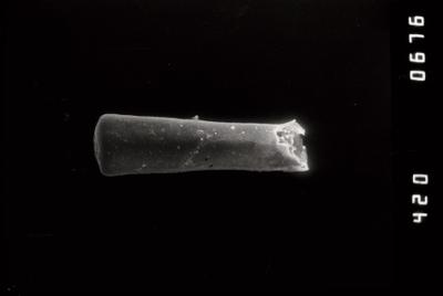
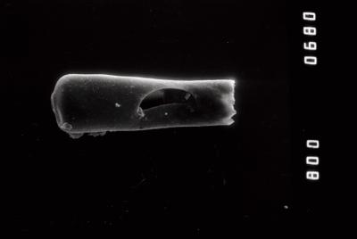
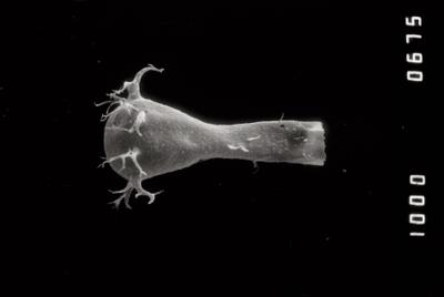
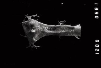
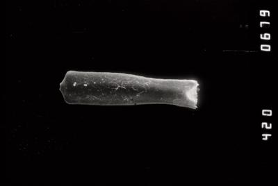
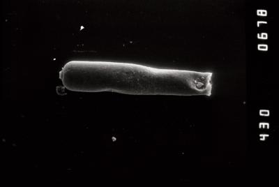
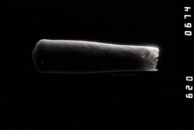
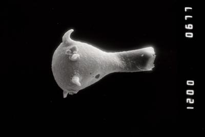
Photos
Tooltip: to show larger image hold Ctrl-key when clicking on image.